Chợ Lách geodata
Chợ Lách (Bến Tre) is a seat of a second-order administrative division; located in Vietnam in Asia/Ho_Chi_Minh (GMT+7) time zone. In our database, there are 94 cities with bigger population. Compared to other cities in Vietnam, 88.3% of cities are located further ↑North; 50.1% of cities are located further ←West and 95.4% of cities have higher elevation than Chợ Lách. Note1


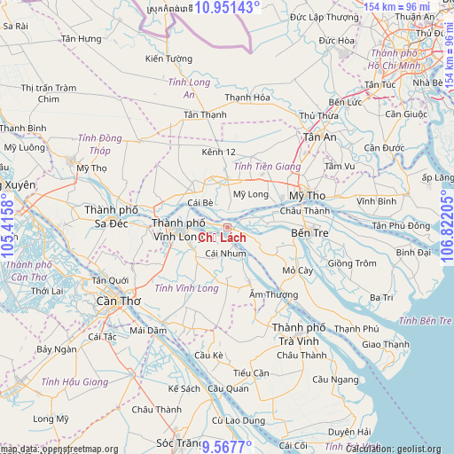
Chợ Lách GPS coordinates[2]
10° 15' 37.152" North, 106° 7' 8.112" East
| Map corner | latitude | longitude |
|---|---|---|
| Upper-left | 10.95143°, | 105.4158° |
| Center: | 10.26032°, | 106.11892° |
| Lower-right: | 9.5677°, | 106.82205° |
| Map W x H: | 153.9×153.9 km | = 95.6×95.6mi |
| max Lat: | 23.27841° ⇑88.3% North |
| Chợ Lách: | 10.26032° |
| min Lat: | ⇓11.7% South 8.65724° |
| min Long | Chợ Lách | max Long |
| 102.4579° | 106.11892° | 112.72541° |
| W 50.1%⇐ | ⇒49.9% E |
Elevation
Elevation of Chợ Lách is 3 m = 10 ft, and this is 126.5 m = 415 ft below average elevation for this country.
| Max E: |
1592 m = 5223 ft | 95.4% |
| Avg. | 129.5 m = 425 ft | |
| Chợ Lách | 3 m = 10 ft | |
Min E: |
-1 m = -3 ft | 4.6% |
See also: Vietnam elevation on elevation.city.
Geographical zone
Chợ Lách is located in North Torrid zone (between Equator and Tropic of Cancer). Distance of Equator is 1140.8 km =708.9 mi to South.| Distance of | km | miles | from Chợ Lách |
|---|---|---|---|
| North Pole | 8866.2 | 5509.2 | to North |
| Arctic Circle | 6260.3 | 3890 | to North |
| Tropic Cancer | 1465.1 | 910.4 | to North |
| Equator | 1140.8 | 708.9 | to South |


Nearby cities:
15 places around Chợ Lách: (largest is in red/bold)
• Bình Minh
38.9 km =24.2 mi,  236°
236°
• Bến Tre
28.2 km =17.5 mi,  94°
94°
• Châu Thành
26.4 km =16.4 mi,  80°
80°
• Chợ Gạo
39 km =24.2 mi, 75°
• Cái Nhum
9.6 km =6 mi,  185°
185°
• Cái Tàu Hạ
27.2 km =16.9 mi,  269°
269°
• Long Hồ
13.9 km =8.6 mi, 237°
• Mỏ Cày
27.6 km =17.1 mi,  120°
120°
• Mỹ Phước
25.4 km =15.8 mi,  18°
18°
• Mỹ Tho
28.6 km =17.8 mi,  67°
67°
• Tam Bình
26.9 km =16.7 mi,  208°
208°
• Tân Hiệp
32.3 km =20.1 mi,  49°
49°
• Vĩnh Long
16.1 km =10 mi, 267°
• Vũng Liêm
19.7 km =12.2 mi,  158°
158°
• Ấp Tân Ngãi
18.2 km =11.3 mi,  99°
99°
Sources, notices
• [Note1] Compared only with cities in Vietnam existing in our database
• [Src1] Map data: © OpenStreetMap contributors (CC-BY-SA)
• [Src2] Other city data from geonames.org with taken over terms of usage.
• [Src3] Geographical zone / Annual Mean Temperature by Robert A. Rohde @ Wikipedia
