Lương Sơn geodata
Lương Sơn (Hòa Bình) is a seat of a second-order administrative division; located in Vietnam in Asia/Ho_Chi_Minh (GMT+7) time zone. In our database, there are 94 cities with bigger population. Compared to other cities in Vietnam, 70.8% of cities are located further ↓South; 75.7% of cities are located further →East and 59.9% of cities have lower elevation than Lương Sơn. Note1


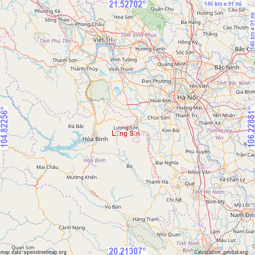
Lương Sơn GPS coordinates[2]
20° 52' 17.328" North, 105° 31' 32.448" East
| Map corner | latitude | longitude |
|---|---|---|
| Upper-left | 21.52702°, | 104.82256° |
| Center: | 20.87148°, | 105.52568° |
| Lower-right: | 20.21307°, | 106.22881° |
| Map W x H: | 146.1×146.1 km | = 90.8×90.8mi |
| max Lat: | 23.27841° ⇑29.2% North |
| Lương Sơn: | 20.87148° |
| min Lat: | ⇓70.8% South 8.65724° |
| min Long | Lương Sơn | max Long |
| 102.4579° | 105.52568° | 112.72541° |
| W 24.3%⇐ | ⇒75.7% E |
Elevation
Elevation of Lương Sơn is 23 m = 75 ft, and this is 106.5 m = 349 ft below average elevation for this country.
| Max E: |
1592 m = 5223 ft | 40.1% |
| Avg. | 129.5 m = 425 ft | |
| Lương Sơn | 23 m = 75 ft | |
Min E: |
-1 m = -3 ft | 59.9% |
See also: Vietnam elevation on elevation.city.
Geographical zone
Lương Sơn is located in North Torrid zone (between Equator and Tropic of Cancer). Distance of this Northern Tropic circle is 285.2 km =177.2 mi to North.| Distance of | km | miles | from Lương Sơn |
|---|---|---|---|
| North Pole | 7686.4 | 4776.1 | to North |
| Arctic Circle | 5080.5 | 3156.9 | to North |
| Tropic Cancer | 285.2 | 177.2 | to North |
| Equator | 2320.7 | 1442 | to South |


Nearby cities:
15 places around Lương Sơn: (largest is in red/bold)
• Bo
22.1 km =13.7 mi,  177°
177°
• Cao Phong
28.3 km =17.6 mi,  228°
228°
• Chúc Sơn
19.2 km =11.9 mi,  72°
72°
• Hà Đông
28.5 km =17.7 mi, 67°
• Hòa Bình
20.5 km =12.7 mi,  252°
252°
• Kim Bài
25.4 km =15.8 mi,  94°
94°
• Kỳ Sơn
18.1 km =11.2 mi,  275°
275°
• Liên Quan
21.4 km =13.3 mi,  15°
15°
• Phùng
27.9 km =17.3 mi,  29°
29°
• Phúc Thọ
25.9 km =16.1 mi,  4°
4°
• Quốc Oai
17.8 km =11.1 mi,  42°
42°
• Sơn Tây
30 km =18.6 mi,  356°
356°
• Trôi
28.9 km =18 mi, 40°
• Vân Đình
29.8 km =18.5 mi,  120°
120°
• Đà Bắc
28.2 km =17.5 mi,  271°
271°
Sources, notices
• [Note1] Compared only with cities in Vietnam existing in our database
• [Src1] Map data: © OpenStreetMap contributors (CC-BY-SA)
• [Src2] Other city data from geonames.org with taken over terms of usage.
• [Src3] Geographical zone / Annual Mean Temperature by Robert A. Rohde @ Wikipedia
