Đồng Lê geodata
Đồng Lê (Quảng Bình) is a seat of a second-order administrative division; located in Vietnam in Asia/Ho_Chi_Minh (GMT+7) time zone. In our database, there are 94 cities with bigger population. Compared to other cities in Vietnam, 52% of cities are located further ↓South; 53.5% of cities are located further →East and 64.6% of cities have lower elevation than Đồng Lê. Note1


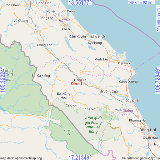
Đồng Lê GPS coordinates[2]
17° 53' 2.004" North, 106° 1' 31.296" East
| Map corner | latitude | longitude |
|---|---|---|
| Upper-left | 18.55177°, | 105.32224° |
| Center: | 17.88389°, | 106.02536° |
| Lower-right: | 17.21349°, | 106.72849° |
| Map W x H: | 148.8×148.8 km | = 92.5×92.5mi |
| max Lat: | 23.27841° ⇑48% North |
| Đồng Lê: | 17.88389° |
| min Lat: | ⇓52% South 8.65724° |
| min Long | Đồng Lê | max Long |
| 102.4579° | 106.02536° | 112.72541° |
| W 46.5%⇐ | ⇒53.5% E |
Elevation
Elevation of Đồng Lê is 33 m = 108 ft, and this is 96.5 m = 317 ft below average elevation for this country.
| Max E: |
1592 m = 5223 ft | 35.4% |
| Avg. | 129.5 m = 425 ft | |
| Đồng Lê | 33 m = 108 ft | |
Min E: |
-1 m = -3 ft | 64.6% |
See also: Vietnam elevation on elevation.city.
Geographical zone
Đồng Lê is located in North Torrid zone (between Equator and Tropic of Cancer). Distance of this Northern Tropic circle is 617.4 km =383.6 mi to North.| Distance of | km | miles | from Đồng Lê |
|---|---|---|---|
| North Pole | 8018.6 | 4982.5 | to North |
| Arctic Circle | 5412.7 | 3363.3 | to North |
| Tropic Cancer | 617.4 | 383.6 | to North |
| Equator | 1988.5 | 1235.6 | to South |


Nearby cities:
15 places around Đồng Lê: (largest is in red/bold)
• Ba Đồn
44.6 km =27.7 mi,  108°
108°
• Cẩm Xuyên
40.8 km =25.4 mi,  356°
356°
• Hoàn Lão
63.4 km =39.4 mi,  121°
121°
• Hà Tĩnh
52.6 km =32.7 mi,  346°
346°
• Hương Khê
47.3 km =29.4 mi,  313°
313°
• Kwang Binh
78.3 km =48.7 mi,  126°
126°
• Kỳ Anh
35 km =21.7 mi,  55°
55°
• Nghi Xuân
91.1 km =56.6 mi,  341°
341°
• Nghèn
68.2 km =42.4 mi, 337°
• Oui Dat
10.6 km =6.6 mi,  213°
213°
• Phố Châu
94.5 km =58.7 mi,  317°
317°
• Quán Hàu
84.2 km =52.3 mi, 129°
• Thạch Hà
56.5 km =35.1 mi, 342°
• Vũ Quang
78.1 km =48.5 mi, 315°
• Đức Thọ
86.6 km =53.8 mi,  327°
327°
Sources, notices
• [Note1] Compared only with cities in Vietnam existing in our database
• [Src1] Map data: © OpenStreetMap contributors (CC-BY-SA)
• [Src2] Other city data from geonames.org with taken over terms of usage.
• [Src3] Geographical zone / Annual Mean Temperature by Robert A. Rohde @ Wikipedia
