Lộc Bình geodata
Lộc Bình (Lạng Sơn) is a seat of a second-order administrative division; located in Vietnam in Asia/Ho_Chi_Minh (GMT+7) time zone. In our database, there are 94 cities with bigger population. Compared to other cities in Vietnam, 88.6% of cities are located further ↓South; 73.4% of cities are located further ←West and 84.3% of cities have lower elevation than Lộc Bình. Note1


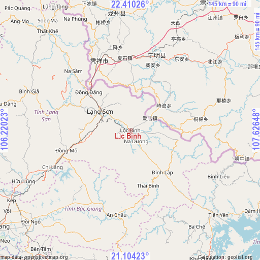
Lộc Bình GPS coordinates[2]
21° 45' 31.428" North, 106° 55' 24.06" East
| Map corner | latitude | longitude |
|---|---|---|
| Upper-left | 22.41026°, | 106.22023° |
| Center: | 21.75873°, | 106.92335° |
| Lower-right: | 21.10423°, | 107.62648° |
| Map W x H: | 145.2×145.2 km | = 90.2×90.2mi |
| max Lat: | 23.27841° ⇑11.4% North |
| Lộc Bình: | 21.75873° |
| min Lat: | ⇓88.6% South 8.65724° |
| min Long | Lộc Bình | max Long |
| 102.4579° | 106.92335° | 112.72541° |
| W 73.4%⇐ | ⇒26.6% E |
Elevation
Elevation of Lộc Bình is 279 m = 915 ft, and this is 149.5 m = 490 ft above average elevation for this country.
| Max E: |
1592 m = 5223 ft | 15.7% |
| Lộc Bình | 279 m 915 ft | |
| Avg. | 129.5 m = 425 ft | |
Min E: |
-1 m = -3 ft | 84.3% |
See also: Vietnam elevation on elevation.city.
Geographical zone
Lộc Bình is located in North Torrid zone (between Equator and Tropic of Cancer). Distance of this Northern Tropic circle is 186.6 km =115.9 mi to North.| Distance of | km | miles | from Lộc Bình |
|---|---|---|---|
| North Pole | 7587.7 | 4714.8 | to North |
| Arctic Circle | 4981.8 | 3095.5 | to North |
| Tropic Cancer | 186.6 | 115.9 | to North |
| Equator | 2419.3 | 1503.3 | to South |


Nearby cities:
15 places around Lộc Bình: (largest is in red/bold)
• An Châu
47.8 km =29.7 mi,  189°
189°
• Bình Gia
61.9 km =38.5 mi,  291°
291°
• Bắc Sơn
64.1 km =39.8 mi,  284°
284°
• Chũ
56.5 km =35.1 mi,  220°
220°
• Hữu Lũng
66.1 km =41.1 mi,  244°
244°
• Lạng Sơn
19.7 km =12.2 mi,  301°
301°
• Thành Phố Uông Bí
82.1 km =51 mi, 191°
• Thị Trấn Cao Lộc
20 km =12.4 mi,  306°
306°
• Thị Trấn Na Sầm
45.9 km =28.5 mi,  316°
316°
• Thị Trấn Thất Khê
72.1 km =44.8 mi, 319°
• Trới
81.2 km =50.5 mi,  175°
175°
• Văn Quan
41.4 km =25.7 mi, 286°
• Đình Lập
29.7 km =18.5 mi,  142°
142°
• Đồi Ngô
74.9 km =46.5 mi,  227°
227°
• Đồng Mỏ
37.4 km =23.2 mi,  252°
252°
Sources, notices
• [Note1] Compared only with cities in Vietnam existing in our database
• [Src1] Map data: © OpenStreetMap contributors (CC-BY-SA)
• [Src2] Other city data from geonames.org with taken over terms of usage.
• [Src3] Geographical zone / Annual Mean Temperature by Robert A. Rohde @ Wikipedia
