Cần Thơ geodata
Cần Thơ (Can Tho) is a seat of a first-order administrative division; located in Vietnam in Asia/Ho_Chi_Minh (GMT+7) time zone. With population of 259,598 people, there are 7 cities with bigger population in this country. Compared to other cities in Vietnam, 92% of cities are located further ↑North; 63.9% of cities are located further →East and 95.4% of cities have higher elevation than Cần Thơ. Note1


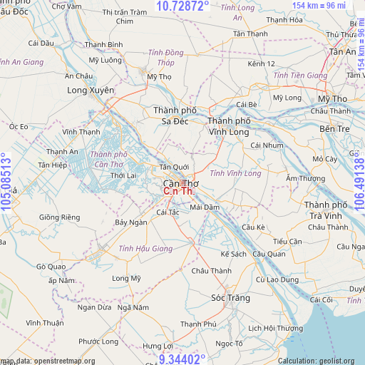
Cần Thơ GPS coordinates[2]
10° 2' 13.596" North, 105° 47' 17.7" East
| Map corner | latitude | longitude |
|---|---|---|
| Upper-left | 10.72872°, | 105.08513° |
| Center: | 10.03711°, | 105.78825° |
| Lower-right: | 9.34402°, | 106.49138° |
| Map W x H: | 154×154 km | = 95.7×95.7mi |
| max Lat: | 23.27841° ⇑92% North |
| Cần Thơ: | 10.03711° |
| min Lat: | ⇓8% South 8.65724° |
| min Long | Cần Thơ | max Long |
| 102.4579° | 105.78825° | 112.72541° |
| W 36.1%⇐ | ⇒63.9% E |
Elevation
Elevation of Cần Thơ is 3 m = 10 ft, and this is 126.5 m = 415 ft below average elevation for this country.
| Max E: |
1592 m = 5223 ft | 95.4% |
| Avg. | 129.5 m = 425 ft | |
| Cần Thơ | 3 m = 10 ft | |
Min E: |
-1 m = -3 ft | 4.6% |
See also: Cần Thơ elevation on elevation.city.
Geographical zone
Cần Thơ is located in North Torrid zone (between Equator and Tropic of Cancer). Distance of Equator is 1116 km =693.5 mi to South.| Distance of | km | miles | from Cần Thơ |
|---|---|---|---|
| North Pole | 8891 | 5524.6 | to North |
| Arctic Circle | 6285.2 | 3905.4 | to North |
| Tropic Cancer | 1489.9 | 925.8 | to North |
| Equator | 1116 | 693.5 | to South |


Nearby cities:
15 places around Cần Thơ: (largest is in red/bold)
• An Hòa
29.3 km =18.2 mi,  350°
350°
• Bình Minh
5.1 km =3.2 mi,  47°
47°
• Bình Thủy
6.7 km =4.2 mi,  307°
307°
• Cái Răng
5.7 km =3.5 mi,  225°
225°
• Cái Tàu Hạ
26.3 km =16.3 mi,  19°
19°
• Một Ngàn
21.4 km =13.3 mi, 234°
• Ngã Bảy
25.1 km =15.6 mi,  171°
171°
• Ngã Sáu
12.8 km =8 mi, 171°
• Phong Điền
14 km =8.7 mi,  251°
251°
• Phụng Hiệp
29.2 km =18.1 mi,  191°
191°
• Sa Dec
28.4 km =17.6 mi, 352°
• Tam Bình
23.2 km =14.4 mi,  86°
86°
• Thới Lai
25.3 km =15.7 mi,  277°
277°
• Trà Ôn
16.8 km =10.4 mi,  119°
119°
• Ô Môn
19.8 km =12.3 mi,  294°
294°
Sources, notices
• [Note1] Compared only with cities in Vietnam existing in our database
• [Src1] Map data: © OpenStreetMap contributors (CC-BY-SA)
• [Src2] Other city data from geonames.org with taken over terms of usage.
• [Src3] Geographical zone / Annual Mean Temperature by Robert A. Rohde @ Wikipedia
