Māwiyah geodata
Māwiyah (Ta‘izz) is a seat of a second-order administrative division; located in Yemen in Asia/Aden (GMT+3) time zone. In our database, there are 51 cities with bigger population. Compared to other cities in Yemen, 88% of cities are located further ↑North; 50% of cities are located further ←West and 50.3% of cities have lower elevation than Māwiyah. Note1


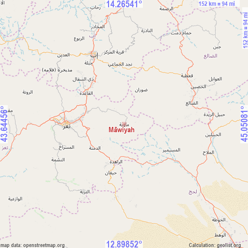
Māwiyah GPS coordinates[2]
13° 34' 58.62" North, 44° 20' 51.648" East
| Map corner | latitude | longitude |
|---|---|---|
| Upper-left | 14.26541°, | 43.64456° |
| Center: | 13.58295°, | 44.34768° |
| Lower-right: | 12.89852°, | 45.05081° |
| Map W x H: | 152×152 km | = 94.4×94.4mi |
| max Lat: | 17.76999° ⇑88% North |
| Māwiyah: | 13.58295° |
| min Lat: | ⇓12% South 12.18576° |
| min Long | Māwiyah | max Long |
| 42.67107° | 44.34768° | 54.01895° |
| W 50%⇐ | ⇒50% E |
Elevation
Elevation of Māwiyah is 1315 m = 4314 ft, and this is 10.2 m = 33 ft above average elevation for this country.
| Max E: |
2791 m = 9157 ft | 49.7% |
| Māwiyah | 1315 m 4314 ft | |
| Avg. | 1304.8 m = 4281 ft | |
Min E: |
4 m = 13 ft | 50.3% |
See also: Yemen elevation on elevation.city.
Geographical zone
Māwiyah is located in North Torrid zone (between Equator and Tropic of Cancer). Distance of this Northern Tropic circle is 1095.6 km =680.8 mi to North.| Distance of | km | miles | from Māwiyah |
|---|---|---|---|
| North Pole | 8496.8 | 5279.7 | to North |
| Arctic Circle | 5890.9 | 3660.4 | to North |
| Tropic Cancer | 1095.6 | 680.8 | to North |
| Equator | 1510.3 | 938.5 | to South |


Nearby cities:
15 places around Māwiyah: (largest is in red/bold)
• Ad Dimnah
23 km =14.3 mi,  231°
231°
• Al Masālīyah
38.5 km =23.9 mi,  261°
261°
• Al Misrākh
37.9 km =23.5 mi,  248°
248°
• Al Musaymīr
32.8 km =20.4 mi,  118°
118°
• As Sayyānī
34.4 km =21.4 mi,  326°
326°
• Aş Şalw
31.6 km =19.6 mi,  206°
206°
• Dhī Jalāl
39.2 km =24.4 mi,  83°
83°
• Dhī as Sufāl
37.6 km =23.4 mi,  318°
318°
• Dār an Nāşir
36 km =22.4 mi,  265°
265°
• Kirsh
28.8 km =17.9 mi,  147°
147°
• Najd al Jamā‘ī
37.1 km =23.1 mi,  356°
356°
• Ta‘izz
35.3 km =21.9 mi, 269°
• Ḑawrān
23.6 km =14.7 mi,  25°
25°
• Ḩawrah
33.2 km =20.6 mi,  221°
221°
• Ḩayfān
30.4 km =18.9 mi,  193°
193°
Sources, notices
• [Note1] Compared only with cities in Yemen existing in our database
• [Src1] Map data: © OpenStreetMap contributors (CC-BY-SA)
• [Src2] Other city data from geonames.org with taken over terms of usage.
• [Src3] Geographical zone / Annual Mean Temperature by Robert A. Rohde @ Wikipedia
