Shibām geodata
Shibām (Al Maḩwīt) is a seat of a second-order administrative division; located in Yemen in Asia/Aden (GMT+3) time zone. In our database, there are 51 cities with bigger population. Compared to other cities in Yemen, 67.2% of cities are located further ↓South; 68.5% of cities are located further →East and 97.1% of cities have lower elevation than Shibām. Note1


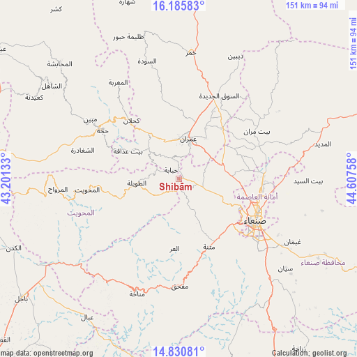
Shibām GPS coordinates[2]
15° 30' 33.948" North, 43° 54' 16.02" East
| Map corner | latitude | longitude |
|---|---|---|
| Upper-left | 16.18583°, | 43.20133° |
| Center: | 15.50943°, | 43.90445° |
| Lower-right: | 14.83081°, | 44.60758° |
| Map W x H: | 150.7×150.7 km | = 93.6×93.6mi |
| max Lat: | 17.76999° ⇑32.8% North |
| Shibām: | 15.50943° |
| min Lat: | ⇓67.2% South 12.18576° |
| min Long | Shibām | max Long |
| 42.67107° | 43.90445° | 54.01895° |
| W 31.5%⇐ | ⇒68.5% E |
Elevation
Elevation of Shibām is 2587 m = 8488 ft, and this is 1282.2 m = 4207 ft above average elevation for this country.
| Max E: |
2791 m = 9157 ft | 2.9% |
| Shibām | 2587 m 8488 ft | |
| Avg. | 1304.8 m = 4281 ft | |
Min E: |
4 m = 13 ft | 97.1% |
See also: Yemen elevation on elevation.city.
Geographical zone
Shibām is located in North Torrid zone (between Equator and Tropic of Cancer). Distance of this Northern Tropic circle is 881.4 km =547.7 mi to North.| Distance of | km | miles | from Shibām |
|---|---|---|---|
| North Pole | 8282.6 | 5146.6 | to North |
| Arctic Circle | 5676.7 | 3527.3 | to North |
| Tropic Cancer | 881.4 | 547.7 | to North |
| Equator | 1724.5 | 1071.6 | to South |


Nearby cities:
15 places around Shibām: (largest is in red/bold)
• Al Khāniq
29.7 km =18.5 mi,  91°
91°
• Al ‘Urr
29.3 km =18.2 mi,  183°
183°
• An Nāşirah
31 km =19.3 mi,  340°
340°
• Ar Rujum
29.7 km =18.5 mi,  258°
258°
• Aş Şarārah
31.9 km =19.8 mi,  353°
353°
• Aţ Ţawīlah
16.9 km =10.5 mi, 264°
• Banī al ‘Awwām
34.9 km =21.7 mi,  283°
283°
• Bayt ‘Adhāqah
24.7 km =15.3 mi,  298°
298°
• Jadder Cemetery
29.7 km =18.5 mi,  99°
99°
• Kuḩlān ‘Affār
31.8 km =19.8 mi,  321°
321°
• Matnah
31.3 km =19.4 mi,  155°
155°
• Qaryat al Qābil
24.8 km =15.4 mi,  105°
105°
• Saḩḩab
16.5 km =10.3 mi,  51°
51°
• Ḩabābah
4.9 km =3 mi, 321°
• ‘Amrān
17.2 km =10.7 mi,  14°
14°
Sources, notices
• [Note1] Compared only with cities in Yemen existing in our database
• [Src1] Map data: © OpenStreetMap contributors (CC-BY-SA)
• [Src2] Other city data from geonames.org with taken over terms of usage.
• [Src3] Geographical zone / Annual Mean Temperature by Robert A. Rohde @ Wikipedia
