Ḩabābah geodata
Ḩabābah (Omran) is a seat of a second-order administrative division; located in Yemen in Asia/Aden (GMT+3) time zone. In our database, there are 51 cities with bigger population. Compared to other cities in Yemen, 67.9% of cities are located further ↓South; 69.5% of cities are located further →East and 97.7% of cities have lower elevation than Ḩabābah. Note1


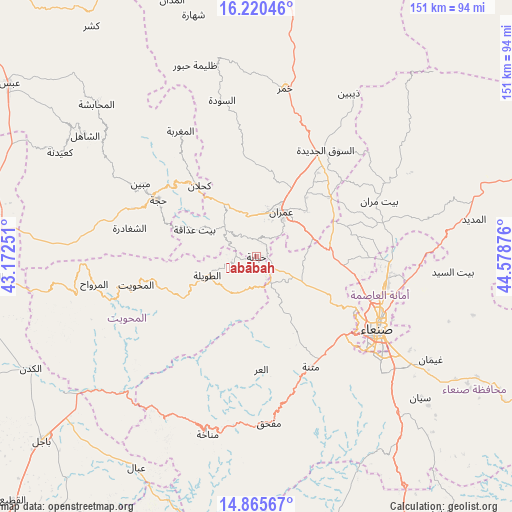
Ḩabābah GPS coordinates[2]
15° 32' 39.048" North, 43° 52' 32.268" East
| Map corner | latitude | longitude |
|---|---|---|
| Upper-left | 16.22046°, | 43.17251° |
| Center: | 15.54418°, | 43.87563° |
| Lower-right: | 14.86567°, | 44.57876° |
| Map W x H: | 150.6×150.6 km | = 93.6×93.6mi |
| max Lat: | 17.76999° ⇑32.1% North |
| Ḩabābah: | 15.54418° |
| min Lat: | ⇓67.9% South 12.18576° |
| min Long | Ḩabābah | max Long |
| 42.67107° | 43.87563° | 54.01895° |
| W 30.5%⇐ | ⇒69.5% E |
Elevation
Elevation of Ḩabābah is 2604 m = 8543 ft, and this is 1299.2 m = 4262 ft above average elevation for this country.
| Max E: |
2791 m = 9157 ft | 2.3% |
| Ḩabābah | 2604 m 8543 ft | |
| Avg. | 1304.8 m = 4281 ft | |
Min E: |
4 m = 13 ft | 97.7% |
See also: Yemen elevation on elevation.city.
Geographical zone
Ḩabābah is located in North Torrid zone (between Equator and Tropic of Cancer). Distance of this Northern Tropic circle is 877.6 km =545.3 mi to North.| Distance of | km | miles | from Ḩabābah |
|---|---|---|---|
| North Pole | 8278.7 | 5144.1 | to North |
| Arctic Circle | 5672.8 | 3524.9 | to North |
| Tropic Cancer | 877.6 | 545.3 | to North |
| Equator | 1728.4 | 1074 | to South |


Nearby cities:
15 places around Ḩabābah: (largest is in red/bold)
• Al Khāniq
33.1 km =20.6 mi,  98°
98°
• Al ‘Urr
33.1 km =20.6 mi,  177°
177°
• An Nāşirah
26.4 km =16.4 mi,  344°
344°
• Ar Rujum
27.8 km =17.3 mi,  249°
249°
• Aş Şarārah
27.8 km =17.3 mi,  358°
358°
• Aţ Ţawīlah
14.8 km =9.2 mi, 247°
• Banī al ‘Awwām
31.2 km =19.4 mi,  277°
277°
• Bayt ‘Adhāqah
20.2 km =12.6 mi,  293°
293°
• Kuḩlān ‘Affār
26.9 km =16.7 mi,  321°
321°
• Qaryat al Qābil
29 km =18 mi,  111°
111°
• Saḩḩab
17.2 km =10.7 mi,  67°
67°
• Sharas
30.6 km =19 mi,  307°
307°
• Shibām
4.9 km =3 mi,  141°
141°
• Ḩajjah
33.4 km =20.8 mi,  300°
300°
• ‘Amrān
14.7 km =9.1 mi,  29°
29°
Sources, notices
• [Note1] Compared only with cities in Yemen existing in our database
• [Src1] Map data: © OpenStreetMap contributors (CC-BY-SA)
• [Src2] Other city data from geonames.org with taken over terms of usage.
• [Src3] Geographical zone / Annual Mean Temperature by Robert A. Rohde @ Wikipedia
