‘Amrān geodata
‘Amrān (Omran) is a seat of a first-order administrative division; located in Yemen in Asia/Aden (GMT+3) time zone. With population of 90,792 people, there are 7 cities with bigger population in this country. Compared to other cities in Yemen, 71.4% of cities are located further ↓South; 68.2% of cities are located further →East and 87.7% of cities have lower elevation than ‘Amrān. Note1


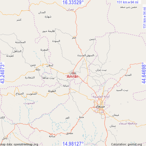
‘Amrān GPS coordinates[2]
15° 39' 33.84" North, 43° 56' 37.86" East
| Map corner | latitude | longitude |
|---|---|---|
| Upper-left | 16.33529°, | 43.24073° |
| Center: | 15.6594°, | 43.94385° |
| Lower-right: | 14.98127°, | 44.64698° |
| Map W x H: | 150.6×150.6 km | = 93.6×93.6mi |
| max Lat: | 17.76999° ⇑28.6% North |
| ‘Amrān: | 15.6594° |
| min Lat: | ⇓71.4% South 12.18576° |
| min Long | ‘Amrān | max Long |
| 42.67107° | 43.94385° | 54.01895° |
| W 31.8%⇐ | ⇒68.2% E |
Elevation
Elevation of ‘Amrān is 2239 m = 7346 ft, and this is 934.2 m = 3065 ft above average elevation for this country.
| Max E: |
2791 m = 9157 ft | 12.3% |
| ‘Amrān | 2239 m 7346 ft | |
| Avg. | 1304.8 m = 4281 ft | |
Min E: |
4 m = 13 ft | 87.7% |
See also: ‘Amrān elevation on elevation.city.
Geographical zone
‘Amrān is located in North Torrid zone (between Equator and Tropic of Cancer). Distance of this Northern Tropic circle is 864.8 km =537.4 mi to North.| Distance of | km | miles | from ‘Amrān |
|---|---|---|---|
| North Pole | 8265.9 | 5136.2 | to North |
| Arctic Circle | 5660 | 3517 | to North |
| Tropic Cancer | 864.8 | 537.4 | to North |
| Equator | 1741.2 | 1081.9 | to South |


Nearby cities:
15 places around ‘Amrān: (largest is in red/bold)
• Al Khāniq
30.9 km =19.2 mi,  124°
124°
• Al Ḩayfah
32.6 km =20.3 mi,  75°
75°
• An Nāşirah
19.2 km =11.9 mi,  311°
311°
• As Sūq al Jadīd
22.3 km =13.9 mi,  34°
34°
• Aş Şarārah
17 km =10.6 mi,  332°
332°
• Aţ Ţawīlah
27.9 km =17.3 mi,  228°
228°
• Bayt Marrān
28.2 km =17.5 mi, 82°
• Bayt ‘Adhāqah
26.3 km =16.3 mi,  259°
259°
• Kuḩlān ‘Affār
25.4 km =15.8 mi,  288°
288°
• Qaryat al Qābil
30.5 km =19 mi,  139°
139°
• Raydah
20.1 km =12.5 mi, 31°
• Saḩḩab
10.7 km =6.6 mi,  126°
126°
• Sharas
32.1 km =19.9 mi,  280°
280°
• Shibām
17.2 km =10.7 mi,  194°
194°
• Ḩabābah
14.7 km =9.1 mi,  209°
209°
Sources, notices
• [Note1] Compared only with cities in Yemen existing in our database
• [Src1] Map data: © OpenStreetMap contributors (CC-BY-SA)
• [Src2] Other city data from geonames.org with taken over terms of usage.
• [Src3] Geographical zone / Annual Mean Temperature by Robert A. Rohde @ Wikipedia
