Al Khāniq geodata
Al Khāniq (Sanaa) is a seat of a second-order administrative division; located in Yemen in Asia/Aden (GMT+3) time zone. With population of 2 people, there are 50 cities with bigger population in this country. Compared to other cities in Yemen, 66.9% of cities are located further ↓South; 57.5% of cities are located further →East and 85.4% of cities have lower elevation than Al Khāniq. Note1


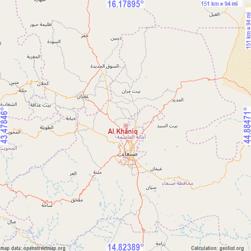
Al Khāniq GPS coordinates[2]
15° 30' 9.108" North, 44° 10' 53.688" East
| Map corner | latitude | longitude |
|---|---|---|
| Upper-left | 16.17895°, | 43.47846° |
| Center: | 15.50253°, | 44.18158° |
| Lower-right: | 14.82389°, | 44.88471° |
| Map W x H: | 150.7×150.7 km | = 93.6×93.6mi |
| max Lat: | 17.76999° ⇑33.1% North |
| Al Khāniq: | 15.50253° |
| min Lat: | ⇓66.9% South 12.18576° |
| min Long | Al Khāniq | max Long |
| 42.67107° | 44.18158° | 54.01895° |
| W 42.5%⇐ | ⇒57.5% E |
Elevation
Elevation of Al Khāniq is 2191 m = 7188 ft, and this is 886.2 m = 2907 ft above average elevation for this country.
| Max E: |
2791 m = 9157 ft | 14.6% |
| Al Khāniq | 2191 m 7188 ft | |
| Avg. | 1304.8 m = 4281 ft | |
Min E: |
4 m = 13 ft | 85.4% |
See also: Yemen elevation on elevation.city.
Geographical zone
Al Khāniq is located in North Torrid zone (between Equator and Tropic of Cancer). Distance of this Northern Tropic circle is 882.2 km =548.2 mi to North.| Distance of | km | miles | from Al Khāniq |
|---|---|---|---|
| North Pole | 8283.3 | 5147 | to North |
| Arctic Circle | 5677.5 | 3527.8 | to North |
| Tropic Cancer | 882.2 | 548.2 | to North |
| Equator | 1723.7 | 1071.1 | to South |


Nearby cities:
15 places around Al Khāniq: (largest is in red/bold)
• Al Madīd
35 km =21.7 mi,  63°
63°
• Al Ḩayfah
26.5 km =16.5 mi,  13°
13°
• Ar Rawḑah
9 km =5.6 mi,  149°
149°
• As Sūq al Jadīd
38.1 km =23.7 mi,  340°
340°
• Bayt Marrān
21.3 km =13.2 mi, 6°
• Jadder Cemetery
4 km =2.5 mi,  185°
185°
• Matnah
32.4 km =20.1 mi,  211°
211°
• Qaryat al Qābil
8.2 km =5.1 mi,  224°
224°
• Raydah
37.8 km =23.5 mi, 336°
• Sanaa
16.7 km =10.4 mi,  170°
170°
• Saḩar
24.8 km =15.4 mi, 146°
• Saḩḩab
20.2 km =12.6 mi,  303°
303°
• Shibām
29.7 km =18.5 mi,  271°
271°
• Ḩabābah
33.1 km =20.6 mi,  278°
278°
• ‘Amrān
30.9 km =19.2 mi, 304°
Sources, notices
• [Note1] Compared only with cities in Yemen existing in our database
• [Src1] Map data: © OpenStreetMap contributors (CC-BY-SA)
• [Src2] Other city data from geonames.org with taken over terms of usage.
• [Src3] Geographical zone / Annual Mean Temperature by Robert A. Rohde @ Wikipedia
