Mūdīyah geodata
Mūdīyah (Abyan) is a seat of a second-order administrative division; located in Yemen in Asia/Aden (GMT+3) time zone. In our database, there are 51 cities with bigger population. Compared to other cities in Yemen, 78.2% of cities are located further ↑North; 79.5% of cities are located further ←West and 69.2% of cities have higher elevation than Mūdīyah. Note1


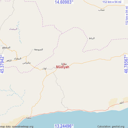
Mūdīyah GPS coordinates[2]
13° 55' 42.24" North, 46° 4' 57.144" East
| Map corner | latitude | longitude |
|---|---|---|
| Upper-left | 14.60983°, | 45.37942° |
| Center: | 13.9284°, | 46.08254° |
| Lower-right: | 13.24496°, | 46.78567° |
| Map W x H: | 151.8×151.8 km | = 94.3×94.3mi |
| max Lat: | 17.76999° ⇑78.2% North |
| Mūdīyah: | 13.9284° |
| min Lat: | ⇓21.8% South 12.18576° |
| min Long | Mūdīyah | max Long |
| 42.67107° | 46.08254° | 54.01895° |
| W 79.5%⇐ | ⇒20.5% E |
Elevation
Elevation of Mūdīyah is 843 m = 2766 ft, and this is 461.8 m = 1515 ft below average elevation for this country.
| Max E: |
2791 m = 9157 ft | 69.2% |
| Avg. | 1304.8 m = 4281 ft | |
| Mūdīyah | 843 m = 2766 ft | |
Min E: |
4 m = 13 ft | 30.8% |
See also: Yemen elevation on elevation.city.
Geographical zone
Mūdīyah is located in North Torrid zone (between Equator and Tropic of Cancer). Distance of this Northern Tropic circle is 1057.2 km =656.9 mi to North.| Distance of | km | miles | from Mūdīyah |
|---|---|---|---|
| North Pole | 8458.4 | 5255.8 | to North |
| Arctic Circle | 5852.5 | 3636.6 | to North |
| Tropic Cancer | 1057.2 | 656.9 | to North |
| Equator | 1548.7 | 962.3 | to South |


Nearby cities:
15 places around Mūdīyah: (largest is in red/bold)
• Al Bayda
55.4 km =34.4 mi,  276°
276°
• Al Wuday‘
18.7 km =11.6 mi,  201°
201°
• Al ‘Āqir
73.5 km =45.7 mi,  345°
345°
• Az Zāhir
64.8 km =40.3 mi,  273°
273°
• Aş Şawma‘ah
35 km =21.7 mi,  299°
299°
• Dhī Nā‘im
71.2 km =44.2 mi,  286°
286°
• Jawf al Maqbābah
28.6 km =17.8 mi,  249°
249°
• Jayshān
37.5 km =23.3 mi,  16°
16°
• Khawrah
56.5 km =35.1 mi,  7°
7°
• Lawdar
23.6 km =14.7 mi,  257°
257°
• Marbāţ
45.1 km =28 mi,  46°
46°
• Maswarah
60.1 km =37.3 mi,  320°
320°
• Mukayrās
44.5 km =27.7 mi, 272°
• Nişāb
78.1 km =48.5 mi,  34°
34°
• Sūq Sibāḩ
75.6 km =47 mi, 260°
Sources, notices
• [Note1] Compared only with cities in Yemen existing in our database
• [Src1] Map data: © OpenStreetMap contributors (CC-BY-SA)
• [Src2] Other city data from geonames.org with taken over terms of usage.
• [Src3] Geographical zone / Annual Mean Temperature by Robert A. Rohde @ Wikipedia
