Khawrah geodata
Khawrah (Shabwah) is a seat of a second-order administrative division; located in Yemen in Asia/Aden (GMT+3) time zone. In our database, there are 51 cities with bigger population. Compared to other cities in Yemen, 61.7% of cities are located further ↑North; 79.9% of cities are located further ←West and 56.8% of cities have higher elevation than Khawrah. Note1


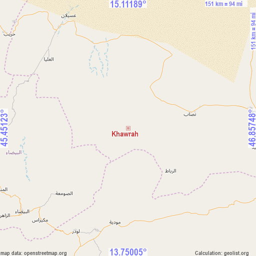
Khawrah GPS coordinates[2]
14° 25' 55.236" North, 46° 9' 15.66" East
| Map corner | latitude | longitude |
|---|---|---|
| Upper-left | 15.11189°, | 45.45123° |
| Center: | 14.43201°, | 46.15435° |
| Lower-right: | 13.75005°, | 46.85748° |
| Map W x H: | 151.4×151.4 km | = 94.1×94.1mi |
| max Lat: | 17.76999° ⇑61.7% North |
| Khawrah: | 14.43201° |
| min Lat: | ⇓38.3% South 12.18576° |
| min Long | Khawrah | max Long |
| 42.67107° | 46.15435° | 54.01895° |
| W 79.9%⇐ | ⇒20.1% E |
Elevation
Elevation of Khawrah is 1199 m = 3934 ft, and this is 105.8 m = 347 ft below average elevation for this country.
| Max E: |
2791 m = 9157 ft | 56.8% |
| Avg. | 1304.8 m = 4281 ft | |
| Khawrah | 1199 m = 3934 ft | |
Min E: |
4 m = 13 ft | 43.2% |
See also: Yemen elevation on elevation.city.
Geographical zone
Khawrah is located in North Torrid zone (between Equator and Tropic of Cancer). Distance of this Northern Tropic circle is 1001.2 km =622.1 mi to North.| Distance of | km | miles | from Khawrah |
|---|---|---|---|
| North Pole | 8402.4 | 5221 | to North |
| Arctic Circle | 5796.5 | 3601.8 | to North |
| Tropic Cancer | 1001.2 | 622.1 | to North |
| Equator | 1604.7 | 997.1 | to South |


Nearby cities:
15 places around Khawrah: (largest is in red/bold)
• AL-khashā Lower
62.8 km =39 mi,  98°
98°
• AL-khashā upper
61.1 km =38 mi, 99°
• Al Ghaylah
64.1 km =39.8 mi,  286°
286°
• Al Ḩazm
65.2 km =40.5 mi,  296°
296°
• Al ‘Āqir
30.2 km =18.8 mi, 300°
• Aş Şawma‘ah
54.2 km =33.7 mi,  224°
224°
• Bayḩān
62.3 km =38.7 mi,  311°
311°
• Jayshān
20.2 km =12.6 mi,  172°
172°
• Khimār
64.2 km =39.9 mi, 101°
• Lawdar
68.4 km =42.5 mi,  206°
206°
• Marbāţ
35.6 km =22.1 mi,  134°
134°
• Maswarah
47.1 km =29.3 mi,  258°
258°
• Mūdīyah
56.5 km =35.1 mi,  187°
187°
• Nişāb
37.5 km =23.3 mi,  77°
77°
• Salābah
62.8 km =39 mi, 101°
Sources, notices
• [Note1] Compared only with cities in Yemen existing in our database
• [Src1] Map data: © OpenStreetMap contributors (CC-BY-SA)
• [Src2] Other city data from geonames.org with taken over terms of usage.
• [Src3] Geographical zone / Annual Mean Temperature by Robert A. Rohde @ Wikipedia
