Mawza‘ geodata
Mawza‘ (Ta‘izz) is a seat of a second-order administrative division; located in Yemen in Asia/Aden (GMT+3) time zone. In our database, there are 51 cities with bigger population. Compared to other cities in Yemen, 93.5% of cities are located further ↑North; 84.7% of cities are located further →East and 84.1% of cities have higher elevation than Mawza‘. Note1


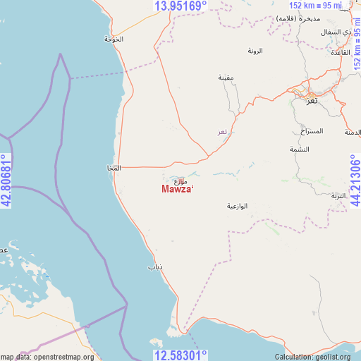
Mawza‘ GPS coordinates[2]
13° 16' 5.916" North, 43° 30' 35.748" East
| Map corner | latitude | longitude |
|---|---|---|
| Upper-left | 13.95169°, | 42.80681° |
| Center: | 13.26831°, | 43.50993° |
| Lower-right: | 12.58301°, | 44.21306° |
| Map W x H: | 152.2×152.2 km | = 94.6×94.6mi |
| max Lat: | 17.76999° ⇑93.5% North |
| Mawza‘: | 13.26831° |
| min Lat: | ⇓6.5% South 12.18576° |
| min Long | Mawza‘ | max Long |
| 42.67107° | 43.50993° | 54.01895° |
| W 15.3%⇐ | ⇒84.7% E |
Elevation
Elevation of Mawza‘ is 202 m = 663 ft, and this is 1102.8 m = 3618 ft below average elevation for this country.
| Max E: |
2791 m = 9157 ft | 84.1% |
| Avg. | 1304.8 m = 4281 ft | |
| Mawza‘ | 202 m = 663 ft | |
Min E: |
4 m = 13 ft | 15.9% |
See also: Yemen elevation on elevation.city.
Geographical zone
Mawza‘ is located in North Torrid zone (between Equator and Tropic of Cancer). Distance of this Northern Tropic circle is 1130.6 km =702.5 mi to North.| Distance of | km | miles | from Mawza‘ |
|---|---|---|---|
| North Pole | 8531.8 | 5301.4 | to North |
| Arctic Circle | 5925.9 | 3682.2 | to North |
| Tropic Cancer | 1130.6 | 702.5 | to North |
| Equator | 1475.3 | 916.7 | to South |


Nearby cities:
15 places around Mawza‘: (largest is in red/bold)
• Al Khawkhah
66.2 km =41.1 mi,  334°
334°
• Al Masālīyah
60.2 km =37.4 mi,  60°
60°
• Al Misrākh
59.2 km =36.8 mi,  68°
68°
• Al Nashmah
51.4 km =31.9 mi, 74°
• Al ‘Ayn
63.4 km =39.4 mi,  83°
83°
• Ar Rawnah
62.8 km =39 mi,  30°
30°
• Ash Shuqayrah
33.4 km =20.8 mi,  116°
116°
• At Turbah
66.8 km =41.5 mi,  95°
95°
• Dhubāb
37.7 km =23.4 mi,  196°
196°
• Dār an Nāşir
63.4 km =39.4 mi, 59°
• Maqbanah
48 km =29.8 mi,  23°
23°
• Qaryat Al kudshi al Ra'inah
61.1 km =38 mi,  39°
39°
• Ta‘izz
65.2 km =40.5 mi, 57°
• Village of ALAMRAH
57.9 km =36 mi, 24°
• Yufrus
51.7 km =32.1 mi, 66°
Sources, notices
• [Note1] Compared only with cities in Yemen existing in our database
• [Src1] Map data: © OpenStreetMap contributors (CC-BY-SA)
• [Src2] Other city data from geonames.org with taken over terms of usage.
• [Src3] Geographical zone / Annual Mean Temperature by Robert A. Rohde @ Wikipedia
