Village of ALAMRAH geodata
Village of ALAMRAH (Ta‘izz) is a farm village; located in Yemen in Asia/Aden (GMT+3) time zone. With population of 4,500 people, there are 29 cities with bigger population in this country. Compared to other cities in Yemen, 85.1% of cities are located further ↑North; 75.3% of cities are located further →East and 64.3% of cities have higher elevation than Village of ALAMRAH. Note1


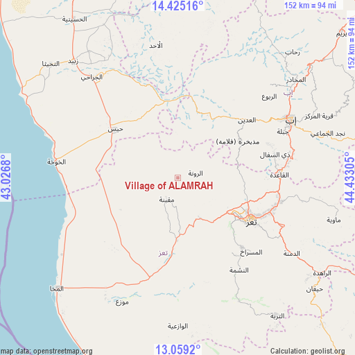
Village of ALAMRAH GPS coordinates[2]
13° 44' 35.448" North, 43° 43' 47.712" East
| Map corner | latitude | longitude |
|---|---|---|
| Upper-left | 14.42516°, | 43.0268° |
| Center: | 13.74318°, | 43.72992° |
| Lower-right: | 13.0592°, | 44.43305° |
| Map W x H: | 151.9×151.9 km | = 94.4×94.4mi |
| max Lat: | 17.76999° ⇑85.1% North |
| Village of ALAMRAH: | 13.74318° |
| min Lat: | ⇓14.9% South 12.18576° |
| min Long | Village of ALAM | max Long |
| 42.67107° | 43.72992° | 54.01895° |
| W 24.7%⇐ | ⇒75.3% E |
Elevation
Elevation of Village of ALAMRAH is 1049 m = 3442 ft, and this is 255.8 m = 839 ft below average elevation for this country.
| Max E: |
2791 m = 9157 ft | 64.3% |
| Avg. | 1304.8 m = 4281 ft | |
| Village of ALAMRAH | 1049 m = 3442 ft | |
Min E: |
4 m = 13 ft | 35.7% |
See also: Yemen elevation on elevation.city.
Geographical zone
Village of ALAMRAH is located in North Torrid zone (between Equator and Tropic of Cancer). Distance of this Northern Tropic circle is 1077.8 km =669.7 mi to North.| Distance of | km | miles | from Village of ALAMRAH |
|---|---|---|---|
| North Pole | 8479 | 5268.6 | to North |
| Arctic Circle | 5873.1 | 3649.4 | to North |
| Tropic Cancer | 1077.8 | 669.7 | to North |
| Equator | 1528.1 | 949.5 | to South |


Nearby cities:
15 places around Village of ALAMRAH: (largest is in red/bold)
• Al Masālīyah
37.1 km =23.1 mi,  129°
129°
• Al ‘Udayn
38.2 km =23.7 mi,  48°
48°
• Ar Ramādī
24.4 km =15.2 mi,  13°
13°
• Ar Rawnah
8 km =5 mi,  79°
79°
• Ar Rubū‘
15.6 km =9.7 mi,  74°
74°
• Dhī as Sufāl
42.8 km =26.6 mi, 76°
• Dār an Nāşir
37.1 km =23.1 mi,  123°
123°
• Maqbanah
9.9 km =6.2 mi,  207°
207°
• Markaz Mudhaykirah
30.5 km =19 mi,  57°
57°
• Markaz al Marīr
30.2 km =18.8 mi,  331°
331°
• Qaryat Al kudshi al Ra'inah
16.4 km =10.2 mi,  110°
110°
• Ta‘izz
36.3 km =22.6 mi, 120°
• Yufrus
39.7 km =24.7 mi,  143°
143°
• Ḩays
33.9 km =21.1 mi,  308°
308°
• Ḩazm al ‘Udayn
43.4 km =27 mi,  43°
43°
Sources, notices
• [Note1] Compared only with cities in Yemen existing in our database
• [Src1] Map data: © OpenStreetMap contributors (CC-BY-SA)
• [Src2] Other city data from geonames.org with taken over terms of usage.
• [Src3] Geographical zone / Annual Mean Temperature by Robert A. Rohde @ Wikipedia
