Al Masālīyah geodata
Al Masālīyah (Ta‘izz) is a seat of a second-order administrative division; located in Yemen in Asia/Aden (GMT+3) time zone. In our database, there are 51 cities with bigger population. Compared to other cities in Yemen, 89% of cities are located further ↑North; 65.9% of cities are located further →East and 86.7% of cities have lower elevation than Al Masālīyah. Note1


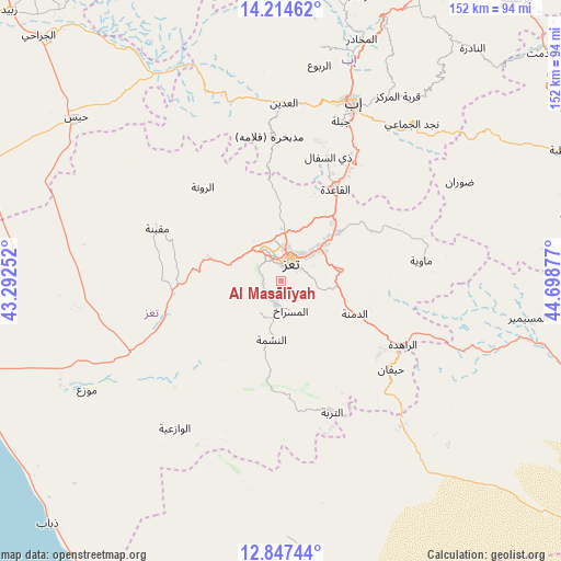
Al Masālīyah GPS coordinates[2]
13° 31' 55.236" North, 43° 59' 44.304" East
| Map corner | latitude | longitude |
|---|---|---|
| Upper-left | 14.21462°, | 43.29252° |
| Center: | 13.53201°, | 43.99564° |
| Lower-right: | 12.84744°, | 44.69877° |
| Map W x H: | 152×152 km | = 94.4×94.4mi |
| max Lat: | 17.76999° ⇑89% North |
| Al Masālīyah: | 13.53201° |
| min Lat: | ⇓11% South 12.18576° |
| min Long | Al Masālīyah | max Long |
| 42.67107° | 43.99564° | 54.01895° |
| W 34.1%⇐ | ⇒65.9% E |
Elevation
Elevation of Al Masālīyah is 2208 m = 7244 ft, and this is 903.2 m = 2963 ft above average elevation for this country.
| Max E: |
2791 m = 9157 ft | 13.3% |
| Al Masālīyah | 2208 m 7244 ft | |
| Avg. | 1304.8 m = 4281 ft | |
Min E: |
4 m = 13 ft | 86.7% |
See also: Yemen elevation on elevation.city.
Geographical zone
Al Masālīyah is located in North Torrid zone (between Equator and Tropic of Cancer). Distance of this Northern Tropic circle is 1101.3 km =684.3 mi to North.| Distance of | km | miles | from Al Masālīyah |
|---|---|---|---|
| North Pole | 8502.4 | 5283.1 | to North |
| Arctic Circle | 5896.6 | 3664 | to North |
| Tropic Cancer | 1101.3 | 684.3 | to North |
| Equator | 1504.6 | 934.9 | to South |


Nearby cities:
15 places around Al Masālīyah: (largest is in red/bold)
• Ad Dimnah
21.9 km =13.6 mi,  113°
113°
• Al Misrākh
8.4 km =5.2 mi,  161°
161°
• Al Nashmah
16 km =9.9 mi,  190°
190°
• Al ‘Ayn
24.8 km =15.4 mi, 155°
• Ar Rawnah
32.5 km =20.2 mi,  320°
320°
• Ar Rubū‘
30.8 km =19.1 mi,  333°
333°
• Aş Şalw
32.9 km =20.4 mi,  133°
133°
• Dhī as Sufāl
36 km =22.4 mi,  20°
20°
• Dār an Nāşir
3.5 km =2.2 mi,  37°
37°
• Maqbanah
36.4 km =22.6 mi,  293°
293°
• Qaryat Al kudshi al Ra'inah
22.1 km =13.7 mi, 322°
• Ta‘izz
5.9 km =3.7 mi,  27°
27°
• Village of ALAMRAH
37.1 km =23.1 mi,  309°
309°
• Yufrus
10 km =6.2 mi,  211°
211°
• Ḩawrah
25.3 km =15.7 mi,  140°
140°
Sources, notices
• [Note1] Compared only with cities in Yemen existing in our database
• [Src1] Map data: © OpenStreetMap contributors (CC-BY-SA)
• [Src2] Other city data from geonames.org with taken over terms of usage.
• [Src3] Geographical zone / Annual Mean Temperature by Robert A. Rohde @ Wikipedia
