Qaryat Al kudshi al Ra'inah geodata
Qaryat Al kudshi al Ra'inah (Ta‘izz) is a populated place; located in Yemen in Asia/Aden (GMT+3) time zone. With population of 750 people, there are 41 cities with bigger population in this country. Compared to other cities in Yemen, 86% of cities are located further ↑North; 69.8% of cities are located further →East and 64% of cities have higher elevation than Qaryat Al kudshi al Ra'inah. Note1
Current local time in Qaryat Al kudshi al Ra'inah:
12:29 AM, WednesdayDifference from your time zone: hours


Qaryat Al kudshi al Ra'inah GPS coordinates[2]
13° 41' 25.944" North, 43° 52' 19.236" East
| Map corner | latitude | longitude |
|---|---|---|
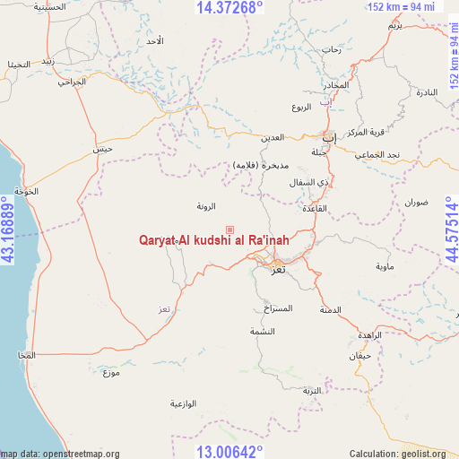
| Upper-left | 14.37268°, | 43.16889° |
| Center: | 13.69054°, | 43.87201° |
| Lower-right: | 13.00642°, | 44.57514° |
| Map W x H: | 151.9×151.9 km | = 94.4×94.4mi |
| max Lat: | 17.76999° ⇑86% North |
| Qaryat Al kudshi al Ra'inah: | 13.69054° |
| min Lat: | ⇓14% South 12.18576° |
| min Long | Qaryat Al kudsh | max Long |
| 42.67107° | 43.87201° | 54.01895° |
| W 30.2%⇐ | ⇒69.8% E |
Elevation
Elevation of Qaryat Al kudshi al Ra'inah is 1052 m = 3451 ft, and this is 252.8 m = 829 ft below average elevation for this country.
| Max E: |
2791 m = 9157 ft | 64% |
| Avg. | 1304.8 m = 4281 ft | |
| Qaryat Al kudshi al Ra'inah | 1052 m = 3451 ft | |
Min E: |
4 m = 13 ft | 36% |
See also: Yemen elevation on elevation.city.
Geographical zone
Qaryat Al kudshi al Ra'inah is located in North Torrid zone (between Equator and Tropic of Cancer). Distance of this Northern Tropic circle is 1083.7 km =673.4 mi to North.| Distance of | km | miles | from Qaryat Al kudshi al Ra'inah |
|---|---|---|---|
| North Pole | 8484.8 | 5272.2 | to North |
| Arctic Circle | 5878.9 | 3653 | to North |
| Tropic Cancer | 1083.7 | 673.4 | to North |
| Equator | 1522.2 | 945.9 | to South |


Nearby cities:
15 places around Qaryat Al kudshi al Ra'inah: (largest is in red/bold)
• Al Masālīyah
22.1 km =13.7 mi,  142°
142°
• Al Misrākh
30.2 km =18.8 mi,  147°
147°
• Al Nashmah
35 km =21.7 mi,  162°
162°
• Al ‘Udayn
33.8 km =21 mi,  23°
23°
• Ar Ramādī
31 km =19.3 mi,  342°
342°
• Ar Rawnah
10.5 km =6.5 mi,  314°
314°
• Ar Rubū‘
10 km =6.2 mi,  358°
358°
• As Sayyānī
36.7 km =22.8 mi,  62°
62°
• Dhī as Sufāl
30.7 km =19.1 mi, 58°
• Dār an Nāşir
21.4 km =13.3 mi,  133°
133°
• Maqbanah
20.2 km =12.6 mi,  261°
261°
• Markaz Mudhaykirah
24.5 km =15.2 mi,  25°
25°
• Ta‘izz
20.3 km =12.6 mi, 127°
• Village of ALAMRAH
16.4 km =10.2 mi,  290°
290°
• Yufrus
27.4 km =17 mi, 162°
Sources, notices
• [Note1] Compared only with cities in Yemen existing in our database
• [Src1] Map data: © OpenStreetMap contributors (CC-BY-SA)
• [Src2] Other city data from geonames.org with taken over terms of usage.
• [Src3] Geographical zone / Annual Mean Temperature by Robert A. Rohde @ Wikipedia
