Manākhah geodata
Manākhah (Sanaa) is a seat of a second-order administrative division; located in Yemen in Asia/Aden (GMT+3) time zone. In our database, there are 51 cities with bigger population. Compared to other cities in Yemen, 54.2% of cities are located further ↓South; 75% of cities are located further →East and 89.3% of cities have lower elevation than Manākhah. Note1


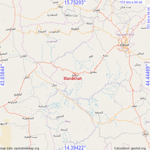
Manākhah GPS coordinates[2]
15° 4' 27.192" North, 43° 44' 29.616" East
| Map corner | latitude | longitude |
|---|---|---|
| Upper-left | 15.75205°, | 43.03844° |
| Center: | 15.07422°, | 43.74156° |
| Lower-right: | 14.39422°, | 44.44469° |
| Map W x H: | 151×151 km | = 93.8×93.8mi |
| max Lat: | 17.76999° ⇑45.8% North |
| Manākhah: | 15.07422° |
| min Lat: | ⇓54.2% South 12.18576° |
| min Long | Manākhah | max Long |
| 42.67107° | 43.74156° | 54.01895° |
| W 25%⇐ | ⇒75% E |
Elevation
Elevation of Manākhah is 2263 m = 7425 ft, and this is 958.2 m = 3144 ft above average elevation for this country.
| Max E: |
2791 m = 9157 ft | 10.7% |
| Manākhah | 2263 m 7425 ft | |
| Avg. | 1304.8 m = 4281 ft | |
Min E: |
4 m = 13 ft | 89.3% |
See also: Yemen elevation on elevation.city.
Geographical zone
Manākhah is located in North Torrid zone (between Equator and Tropic of Cancer). Distance of this Northern Tropic circle is 929.8 km =577.8 mi to North.| Distance of | km | miles | from Manākhah |
|---|---|---|---|
| North Pole | 8331 | 5176.6 | to North |
| Arctic Circle | 5725.1 | 3557.4 | to North |
| Tropic Cancer | 929.8 | 577.8 | to North |
| Equator | 1676.1 | 1041.5 | to South |


Nearby cities:
15 places around Manākhah: (largest is in red/bold)
• Al Jabīn
43.9 km =27.3 mi,  200°
200°
• Al Jum‘ah
44.4 km =27.6 mi,  147°
147°
• Al Khamīs
27.6 km =17.1 mi,  296°
296°
• Al ‘Urr
24.8 km =15.4 mi,  39°
39°
• Ar Rujum
44.2 km =27.5 mi,  344°
344°
• As Sukhnah
45.2 km =28.1 mi,  226°
226°
• Aş Şafaqayn
48.3 km =30 mi,  314°
314°
• Aţ Ţawīlah
46.7 km =29 mi,  0°
0°
• Aḑ Ḑil‘
45.5 km =28.3 mi,  169°
169°
• Mafḩaq
17.6 km =10.9 mi,  80°
80°
• Markaz Bilād aţ Ţa‘ām
34.7 km =21.6 mi,  219°
219°
• Matnah
36.3 km =22.6 mi,  56°
56°
• Matwaḩ
10.7 km =6.6 mi,  266°
266°
• Riqāb
36.3 km =22.6 mi, 234°
• ‘Ubāl
23.2 km =14.4 mi,  245°
245°
Sources, notices
• [Note1] Compared only with cities in Yemen existing in our database
• [Src1] Map data: © OpenStreetMap contributors (CC-BY-SA)
• [Src2] Other city data from geonames.org with taken over terms of usage.
• [Src3] Geographical zone / Annual Mean Temperature by Robert A. Rohde @ Wikipedia
