Al Khamīs geodata
Al Khamīs (Al Maḩwīt) is a seat of a second-order administrative division; located in Yemen in Asia/Aden (GMT+3) time zone. In our database, there are 51 cities with bigger population. Compared to other cities in Yemen, 56.2% of cities are located further ↓South; 84.4% of cities are located further →East and 80.2% of cities have higher elevation than Al Khamīs. Note1


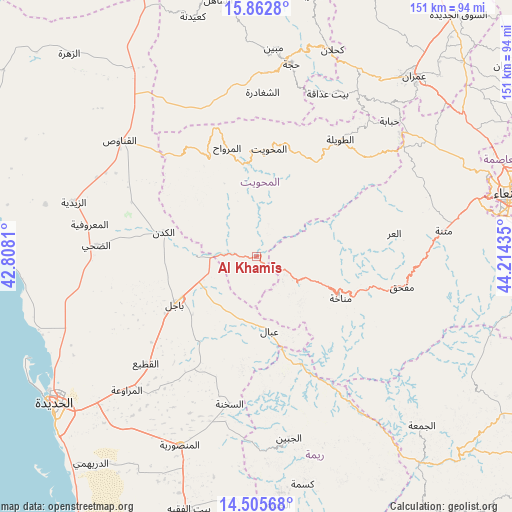
Al Khamīs GPS coordinates[2]
15° 11' 7.188" North, 43° 30' 40.392" East
| Map corner | latitude | longitude |
|---|---|---|
| Upper-left | 15.8628°, | 42.8081° |
| Center: | 15.18533°, | 43.51122° |
| Lower-right: | 14.50568°, | 44.21435° |
| Map W x H: | 150.9×150.9 km | = 93.8×93.8mi |
| max Lat: | 17.76999° ⇑43.8% North |
| Al Khamīs: | 15.18533° |
| min Lat: | ⇓56.2% South 12.18576° |
| min Long | Al Khamīs | max Long |
| 42.67107° | 43.51122° | 54.01895° |
| W 15.6%⇐ | ⇒84.4% E |
Elevation
Elevation of Al Khamīs is 493 m = 1617 ft, and this is 811.8 m = 2663 ft below average elevation for this country.
| Max E: |
2791 m = 9157 ft | 80.2% |
| Avg. | 1304.8 m = 4281 ft | |
| Al Khamīs | 493 m = 1617 ft | |
Min E: |
4 m = 13 ft | 19.8% |
See also: Yemen elevation on elevation.city.
Geographical zone
Al Khamīs is located in North Torrid zone (between Equator and Tropic of Cancer). Distance of this Northern Tropic circle is 917.5 km =570.1 mi to North.| Distance of | km | miles | from Al Khamīs |
|---|---|---|---|
| North Pole | 8318.6 | 5168.9 | to North |
| Arctic Circle | 5712.7 | 3549.7 | to North |
| Tropic Cancer | 917.5 | 570.1 | to North |
| Equator | 1688.5 | 1049.2 | to South |


Nearby cities:
15 places around Al Khamīs: (largest is in red/bold)
• Al Maḩwīt
31.9 km =19.8 mi,  6°
6°
• Al Mighlāf
36.4 km =22.6 mi,  288°
288°
• Al Mirwāḩ
33.1 km =20.6 mi,  344°
344°
• Al ‘Urr
41 km =25.5 mi,  80°
80°
• Ar Rujum
33 km =20.5 mi,  23°
23°
• Aş Şafaqayn
23.7 km =14.7 mi, 335°
• Aţ Ţawīlah
42.7 km =26.5 mi,  36°
36°
• Banī Ḩujjāj
33 km =20.5 mi,  321°
321°
• Bājil
27.8 km =17.3 mi,  239°
239°
• Mafḩaq
43.1 km =26.8 mi,  102°
102°
• Manākhah
27.6 km =17.1 mi,  116°
116°
• Markaz Bilād aţ Ţa‘ām
39.2 km =24.4 mi,  176°
176°
• Matwaḩ
19.2 km =11.9 mi,  132°
132°
• Riqāb
33.7 km =20.9 mi,  188°
188°
• ‘Ubāl
22.2 km =13.8 mi,  170°
170°
Sources, notices
• [Note1] Compared only with cities in Yemen existing in our database
• [Src1] Map data: © OpenStreetMap contributors (CC-BY-SA)
• [Src2] Other city data from geonames.org with taken over terms of usage.
• [Src3] Geographical zone / Annual Mean Temperature by Robert A. Rohde @ Wikipedia
