Mafḩaq geodata
Mafḩaq (Sanaa) is a seat of a second-order administrative division; located in Yemen in Asia/Aden (GMT+3) time zone. In our database, there are 51 cities with bigger population. Compared to other cities in Yemen, 54.9% of cities are located further ↓South; 68.8% of cities are located further →East and 62% of cities have lower elevation than Mafḩaq. Note1


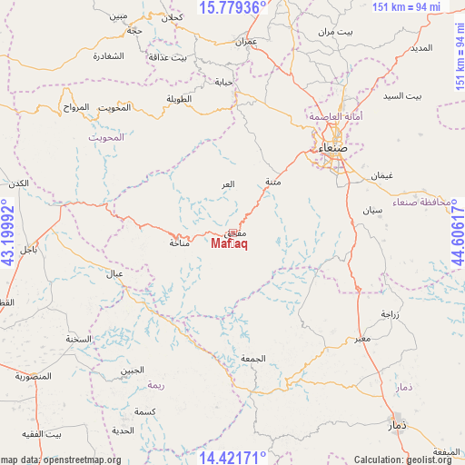
Mafḩaq GPS coordinates[2]
15° 6' 5.832" North, 43° 54' 10.944" East
| Map corner | latitude | longitude |
|---|---|---|
| Upper-left | 15.77936°, | 43.19992° |
| Center: | 15.10162°, | 43.90304° |
| Lower-right: | 14.42171°, | 44.60617° |
| Map W x H: | 151×151 km | = 93.8×93.8mi |
| max Lat: | 17.76999° ⇑45.1% North |
| Mafḩaq: | 15.10162° |
| min Lat: | ⇓54.9% South 12.18576° |
| min Long | Mafḩaq | max Long |
| 42.67107° | 43.90304° | 54.01895° |
| W 31.2%⇐ | ⇒68.8% E |
Elevation
Elevation of Mafḩaq is 1646 m = 5400 ft, and this is 341.2 m = 1119 ft above average elevation for this country.
| Max E: |
2791 m = 9157 ft | 38% |
| Mafḩaq | 1646 m 5400 ft | |
| Avg. | 1304.8 m = 4281 ft | |
Min E: |
4 m = 13 ft | 62% |
See also: Yemen elevation on elevation.city.
Geographical zone
Mafḩaq is located in North Torrid zone (between Equator and Tropic of Cancer). Distance of this Northern Tropic circle is 926.8 km =575.9 mi to North.| Distance of | km | miles | from Mafḩaq |
|---|---|---|---|
| North Pole | 8327.9 | 5174.7 | to North |
| Arctic Circle | 5722 | 3555.5 | to North |
| Tropic Cancer | 926.8 | 575.9 | to North |
| Equator | 1679.1 | 1043.3 | to South |


Nearby cities:
15 places around Mafḩaq: (largest is in red/bold)
• Al Jum‘ah
41 km =25.5 mi,  170°
170°
• Al Khamīs
43.1 km =26.8 mi,  282°
282°
• Al ‘Urr
16.2 km =10.1 mi,  354°
354°
• Ar Rujum
49.1 km =30.5 mi,  323°
323°
• Aţ Ţawīlah
46.7 km =29 mi,  339°
339°
• Aḑ Ḑil‘
48.6 km =30.2 mi,  190°
190°
• Manākhah
17.6 km =10.9 mi,  260°
260°
• Matnah
21.3 km =13.2 mi,  37°
37°
• Matwaḩ
28.3 km =17.6 mi, 262°
• Qaryat al Qābil
45.6 km =28.3 mi,  31°
31°
• Sanaa
43 km =26.7 mi,  49°
49°
• Sayyān
45.9 km =28.5 mi,  80°
80°
• Shibām
45.3 km =28.1 mi,  0°
0°
• Wa‘lān
40.2 km =25 mi,  94°
94°
• ‘Ubāl
40.5 km =25.2 mi,  251°
251°
Sources, notices
• [Note1] Compared only with cities in Yemen existing in our database
• [Src1] Map data: © OpenStreetMap contributors (CC-BY-SA)
• [Src2] Other city data from geonames.org with taken over terms of usage.
• [Src3] Geographical zone / Annual Mean Temperature by Robert A. Rohde @ Wikipedia
