‘Ubāl geodata
‘Ubāl (Al Hudaydah) is a seat of a second-order administrative division; located in Yemen in Asia/Aden (GMT+3) time zone. In our database, there are 51 cities with bigger population. Compared to other cities in Yemen, 51.9% of cities are located further ↓South; 83.1% of cities are located further →East and 79.9% of cities have higher elevation than ‘Ubāl. Note1


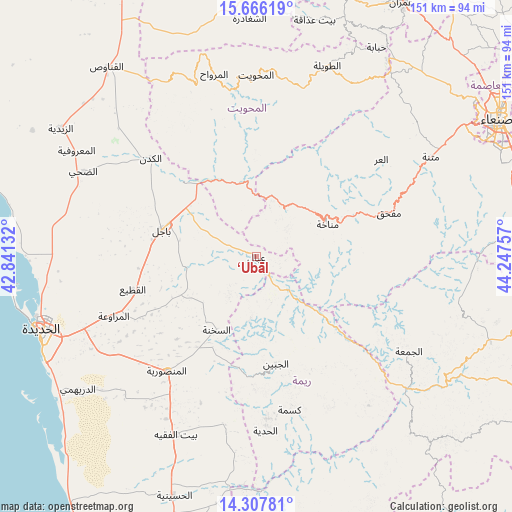
‘Ubāl GPS coordinates[2]
14° 59' 17.088" North, 43° 32' 39.984" East
| Map corner | latitude | longitude |
|---|---|---|
| Upper-left | 15.66619°, | 42.84132° |
| Center: | 14.98808°, | 43.54444° |
| Lower-right: | 14.30781°, | 44.24757° |
| Map W x H: | 151×151 km | = 93.8×93.8mi |
| max Lat: | 17.76999° ⇑48.1% North |
| ‘Ubāl: | 14.98808° |
| min Lat: | ⇓51.9% South 12.18576° |
| min Long | ‘Ubāl | max Long |
| 42.67107° | 43.54444° | 54.01895° |
| W 16.9%⇐ | ⇒83.1% E |
Elevation
Elevation of ‘Ubāl is 494 m = 1621 ft, and this is 810.8 m = 2660 ft below average elevation for this country.
| Max E: |
2791 m = 9157 ft | 79.9% |
| Avg. | 1304.8 m = 4281 ft | |
| ‘Ubāl | 494 m = 1621 ft | |
Min E: |
4 m = 13 ft | 20.1% |
See also: Yemen elevation on elevation.city.
Geographical zone
‘Ubāl is located in North Torrid zone (between Equator and Tropic of Cancer). Distance of this Northern Tropic circle is 939.4 km =583.7 mi to North.| Distance of | km | miles | from ‘Ubāl |
|---|---|---|---|
| North Pole | 8340.5 | 5182.5 | to North |
| Arctic Circle | 5734.7 | 3563.4 | to North |
| Tropic Cancer | 939.4 | 583.7 | to North |
| Equator | 1666.5 | 1035.5 | to South |


Nearby cities:
15 places around ‘Ubāl: (largest is in red/bold)
• Al Jabīn
32.1 km =19.9 mi,  169°
169°
• Al Khamīs
22.2 km =13.8 mi,  350°
350°
• Al Manşūrīyah
42.7 km =26.5 mi,  218°
218°
• Al Marāwi‘ah
45.5 km =28.3 mi,  247°
247°
• Al ‘Urr
46.8 km =29.1 mi,  52°
52°
• As Sukhnah
24.5 km =15.2 mi,  208°
208°
• Aş Şafaqayn
45.5 km =28.3 mi,  342°
342°
• Aḑ Ḑil‘
45.8 km =28.5 mi,  140°
140°
• Bājil
28.7 km =17.8 mi,  285°
285°
• Kusmah
46.3 km =28.8 mi, 167°
• Mafḩaq
40.5 km =25.2 mi,  71°
71°
• Manākhah
23.2 km =14.4 mi, 65°
• Markaz Bilād aţ Ţa‘ām
17.2 km =10.7 mi,  182°
182°
• Matwaḩ
13.7 km =8.5 mi, 49°
• Riqāb
14.2 km =8.8 mi, 216°
Sources, notices
• [Note1] Compared only with cities in Yemen existing in our database
• [Src1] Map data: © OpenStreetMap contributors (CC-BY-SA)
• [Src2] Other city data from geonames.org with taken over terms of usage.
• [Src3] Geographical zone / Annual Mean Temperature by Robert A. Rohde @ Wikipedia
