Al Ma‘allā’ geodata
Al Ma‘allā’ (Aden) is a seat of a second-order administrative division; located in Yemen in Asia/Aden (GMT+3) time zone. In our database, there are 51 cities with bigger population. Compared to other cities in Yemen, 97.7% of cities are located further ↑North; 66.2% of cities are located further ←West and 95.5% of cities have higher elevation than Al Ma‘allā’. Note1


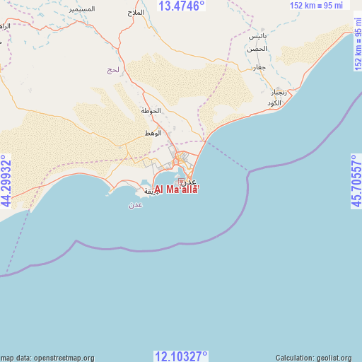
Al Ma‘allā’ GPS coordinates[2]
12° 47' 23.532" North, 45° 0' 8.784" East
| Map corner | latitude | longitude |
|---|---|---|
| Upper-left | 13.4746°, | 44.29932° |
| Center: | 12.78987°, | 45.00244° |
| Lower-right: | 12.10327°, | 45.70557° |
| Map W x H: | 152.5×152.5 km | = 94.8×94.8mi |
| max Lat: | 17.76999° ⇑97.7% North |
| Al Ma‘allā’: | 12.78987° |
| min Lat: | ⇓2.3% South 12.18576° |
| min Long | Al Ma‘allā� | max Long |
| 42.67107° | 45.00244° | 54.01895° |
| W 66.2%⇐ | ⇒33.8% E |
Elevation
Elevation of Al Ma‘allā’ is 13 m = 43 ft, and this is 1291.8 m = 4238 ft below average elevation for this country.
| Max E: |
2791 m = 9157 ft | 95.5% |
| Avg. | 1304.8 m = 4281 ft | |
| Al Ma‘allā’ | 13 m = 43 ft | |
Min E: |
4 m = 13 ft | 4.5% |
See also: Yemen elevation on elevation.city.
Geographical zone
Al Ma‘allā’ is located in North Torrid zone (between Equator and Tropic of Cancer). Distance of this Northern Tropic circle is 1183.8 km =735.6 mi to North.| Distance of | km | miles | from Al Ma‘allā’ |
|---|---|---|---|
| North Pole | 8585 | 5334.5 | to North |
| Arctic Circle | 5979.1 | 3715.2 | to North |
| Tropic Cancer | 1183.8 | 735.6 | to North |
| Equator | 1422.1 | 883.7 | to South |


Nearby cities:
15 places around Al Ma‘allā’: (largest is in red/bold)
• Aden
3.9 km =2.4 mi,  107°
107°
• Al Burayqah
14 km =8.7 mi,  246°
246°
• Al Manşūrah
8.1 km =5 mi,  343°
343°
• Al Milāḩ
73.3 km =45.5 mi, 344°
• Al Musaymīr
83.9 km =52.1 mi,  330°
330°
• Al Ḩabīlayn
82.8 km =51.4 mi,  348°
348°
• Ash Shaykh ‘Uthmān
9.7 km =6 mi, 354°
• At Tawāhī
2.5 km =1.6 mi,  256°
256°
• Crater
4.2 km =2.6 mi, 112°
• Ja‘ār
58.3 km =36.2 mi,  34°
34°
• Khawr Maksar
4.2 km =2.6 mi,  53°
53°
• Kirsh
84.6 km =52.6 mi,  319°
319°
• Laḩij
32.4 km =20.1 mi, 336°
• Zinjibār
55.7 km =34.6 mi, 47°
• Ţawr al Bāḩah
87.7 km =54.5 mi,  299°
299°
Sources, notices
• [Note1] Compared only with cities in Yemen existing in our database
• [Src1] Map data: © OpenStreetMap contributors (CC-BY-SA)
• [Src2] Other city data from geonames.org with taken over terms of usage.
• [Src3] Geographical zone / Annual Mean Temperature by Robert A. Rohde @ Wikipedia
