Laḩij geodata
Laḩij is a seat of a first-order administrative division; located in Yemen in Asia/Aden (GMT+3) time zone. With population of 23,375 people, there are 19 cities with bigger population in this country. Compared to other cities in Yemen, 95.8% of cities are located further ↑North; 64% of cities are located further ←West and 86% of cities have higher elevation than Laḩij. Note1


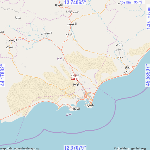
Laḩij GPS coordinates[2]
13° 3' 24.012" North, 44° 52' 54.984" East
| Map corner | latitude | longitude |
|---|---|---|
| Upper-left | 13.74065°, | 44.17882° |
| Center: | 13.05667°, | 44.88194° |
| Lower-right: | 12.37079°, | 45.58507° |
| Map W x H: | 152.3×152.3 km | = 94.6×94.6mi |
| max Lat: | 17.76999° ⇑95.8% North |
| Laḩij: | 13.05667° |
| min Lat: | ⇓4.2% South 12.18576° |
| min Long | Laḩij | max Long |
| 42.67107° | 44.88194° | 54.01895° |
| W 64%⇐ | ⇒36% E |
Elevation
Elevation of Laḩij is 136 m = 446 ft, and this is 1168.8 m = 3835 ft below average elevation for this country.
| Max E: |
2791 m = 9157 ft | 86% |
| Avg. | 1304.8 m = 4281 ft | |
| Laḩij | 136 m = 446 ft | |
Min E: |
4 m = 13 ft | 14% |
See also: Yemen elevation on elevation.city.
Geographical zone
Laḩij is located in North Torrid zone (between Equator and Tropic of Cancer). Distance of this Northern Tropic circle is 1154.2 km =717.2 mi to North.| Distance of | km | miles | from Laḩij |
|---|---|---|---|
| North Pole | 8555.3 | 5316 | to North |
| Arctic Circle | 5949.4 | 3696.8 | to North |
| Tropic Cancer | 1154.2 | 717.2 | to North |
| Equator | 1451.8 | 902.1 | to South |


Nearby cities:
15 places around Laḩij: (largest is in red/bold)
• Aden
35.1 km =21.8 mi,  151°
151°
• Al Burayqah
35.3 km =21.9 mi,  179°
179°
• Al Manşūrah
24.4 km =15.2 mi, 153°
• Al Ma‘allā’
32.4 km =20.1 mi,  156°
156°
• Al Milāḩ
41.5 km =25.8 mi,  351°
351°
• Al Musaymīr
51.8 km =32.2 mi,  326°
326°
• Al Ḩabīlayn
51.6 km =32.1 mi,  356°
356°
• Ash Shaykh ‘Uthmān
23.3 km =14.5 mi, 148°
• At Tawāhī
32.1 km =19.9 mi, 160°
• Crater
35.6 km =22.1 mi, 151°
• Ja‘ār
49.5 km =30.8 mi,  68°
68°
• Khawr Maksar
31.7 km =19.7 mi, 148°
• Kirsh
54.5 km =33.9 mi,  308°
308°
• Zinjibār
54.6 km =33.9 mi,  81°
81°
• Ḩabīl al Jabr
61.9 km =38.5 mi,  10°
10°
Sources, notices
• [Note1] Compared only with cities in Yemen existing in our database
• [Src1] Map data: © OpenStreetMap contributors (CC-BY-SA)
• [Src2] Other city data from geonames.org with taken over terms of usage.
• [Src3] Geographical zone / Annual Mean Temperature by Robert A. Rohde @ Wikipedia
