Ash Shaykh ‘Uthmān geodata
Ash Shaykh ‘Uthmān (Aden) is a seat of a second-order administrative division; located in Yemen in Asia/Aden (GMT+3) time zone. In our database, there are 51 cities with bigger population. Compared to other cities in Yemen, 96.8% of cities are located further ↑North; 65.9% of cities are located further ←West and 95.8% of cities have higher elevation than Ash Shaykh ‘Uthmān. Note1


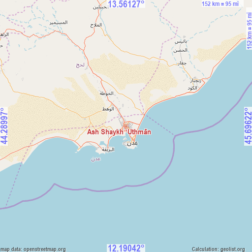
Ash Shaykh ‘Uthmān GPS coordinates[2]
12° 52' 36.408" North, 44° 59' 35.124" East
| Map corner | latitude | longitude |
|---|---|---|
| Upper-left | 13.56127°, | 44.28997° |
| Center: | 12.87678°, | 44.99309° |
| Lower-right: | 12.19042°, | 45.69622° |
| Map W x H: | 152.4×152.4 km | = 94.7×94.7mi |
| max Lat: | 17.76999° ⇑96.8% North |
| Ash Shaykh ‘Uthmān: | 12.87678° |
| min Lat: | ⇓3.2% South 12.18576° |
| min Long | Ash Shaykh ‘U | max Long |
| 42.67107° | 44.99309° | 54.01895° |
| W 65.9%⇐ | ⇒34.1% E |
Elevation
Elevation of Ash Shaykh ‘Uthmān is 12 m = 39 ft, and this is 1292.8 m = 4241 ft below average elevation for this country.
| Max E: |
2791 m = 9157 ft | 95.8% |
| Avg. | 1304.8 m = 4281 ft | |
| Ash Shaykh ‘Uthmān | 12 m = 39 ft | |
Min E: |
4 m = 13 ft | 4.2% |
See also: Yemen elevation on elevation.city.
Geographical zone
Ash Shaykh ‘Uthmān is located in North Torrid zone (between Equator and Tropic of Cancer). Distance of this Northern Tropic circle is 1174.2 km =729.6 mi to North.| Distance of | km | miles | from Ash Shaykh ‘Uthmān |
|---|---|---|---|
| North Pole | 8575.3 | 5328.4 | to North |
| Arctic Circle | 5969.4 | 3709.2 | to North |
| Tropic Cancer | 1174.2 | 729.6 | to North |
| Equator | 1431.8 | 889.7 | to South |


Nearby cities:
15 places around Ash Shaykh ‘Uthmān: (largest is in red/bold)
• Aden
11.8 km =7.3 mi,  156°
156°
• Al Burayqah
19.3 km =12 mi,  217°
217°
• Al Manşūrah
2.2 km =1.4 mi,  213°
213°
• Al Ma‘allā’
9.7 km =6 mi,  174°
174°
• Al Milāḩ
63.7 km =39.6 mi,  343°
343°
• Al Musaymīr
75.2 km =46.7 mi,  327°
327°
• Al Ḩabīlayn
73.2 km =45.5 mi,  347°
347°
• At Tawāhī
10.3 km =6.4 mi,  187°
187°
• Crater
12.3 km =7.6 mi, 156°
• Ja‘ār
51.3 km =31.9 mi,  41°
41°
• Khawr Maksar
8.4 km =5.2 mi,  148°
148°
• Kirsh
76.9 km =47.8 mi,  314°
314°
• Laḩij
23.3 km =14.5 mi, 328°
• Zinjibār
50.5 km =31.4 mi,  56°
56°
• Ḩabīl al Jabr
80.9 km =50.3 mi,  359°
359°
Sources, notices
• [Note1] Compared only with cities in Yemen existing in our database
• [Src1] Map data: © OpenStreetMap contributors (CC-BY-SA)
• [Src2] Other city data from geonames.org with taken over terms of usage.
• [Src3] Geographical zone / Annual Mean Temperature by Robert A. Rohde @ Wikipedia
