Aden geodata
Aden is a seat of a first-order administrative division; located in Yemen in Asia/Aden (GMT+3) time zone. With population of 550,602 people, there are 3 cities with bigger population in this country. Compared to other cities in Yemen, 98.4% of cities are located further ↑North; 67.5% of cities are located further ←West and 94.5% of cities have higher elevation than Aden. Note1


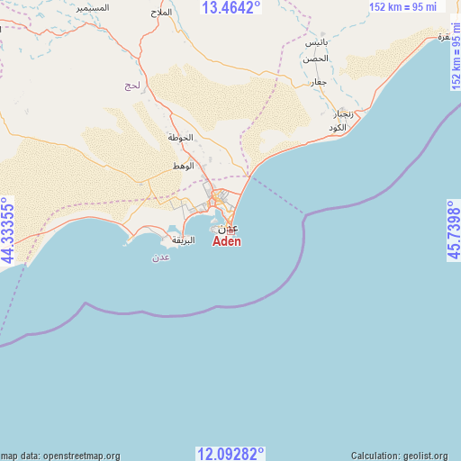
Aden GPS coordinates[2]
12° 46' 45.984" North, 45° 2' 12.012" East
| Map corner | latitude | longitude |
|---|---|---|
| Upper-left | 13.4642°, | 44.33355° |
| Center: | 12.77944°, | 45.03667° |
| Lower-right: | 12.09282°, | 45.7398° |
| Map W x H: | 152.5×152.5 km | = 94.8×94.8mi |
| max Lat: | 17.76999° ⇑98.4% North |
| Aden: | 12.77944° |
| min Lat: | ⇓1.6% South 12.18576° |
| min Long | Aden | max Long |
| 42.67107° | 45.03667° | 54.01895° |
| W 67.5%⇐ | ⇒32.5% E |
Elevation
Elevation of Aden is 16 m = 52 ft, and this is 1288.8 m = 4228 ft below average elevation for this country.
| Max E: |
2791 m = 9157 ft | 94.5% |
| Avg. | 1304.8 m = 4281 ft | |
| Aden | 16 m = 52 ft | |
Min E: |
4 m = 13 ft | 5.5% |
See also: Aden elevation on elevation.city.
Geographical zone
Aden is located in North Torrid zone (between Equator and Tropic of Cancer). Distance of this Northern Tropic circle is 1185 km =736.3 mi to North.| Distance of | km | miles | from Aden |
|---|---|---|---|
| North Pole | 8586.1 | 5335.2 | to North |
| Arctic Circle | 5980.2 | 3715.9 | to North |
| Tropic Cancer | 1185 | 736.3 | to North |
| Equator | 1420.9 | 882.9 | to South |


Nearby cities:
15 places around Aden: (largest is in red/bold)
• Al Burayqah
17.1 km =10.6 mi,  254°
254°
• Al Manşūrah
10.8 km =6.7 mi,  326°
326°
• Al Ma‘allā’
3.9 km =2.4 mi,  287°
287°
• Al Milāḩ
75.5 km =46.9 mi,  342°
342°
• Al Musaymīr
86.8 km =53.9 mi, 328°
• Al Ḩabīlayn
84.8 km =52.7 mi,  346°
346°
• Ash Shaykh ‘Uthmān
11.8 km =7.3 mi, 336°
• At Tawāhī
6.2 km =3.9 mi,  275°
275°
• Crater
0.5 km =0.3 mi,  155°
155°
• Ja‘ār
57.3 km =35.6 mi,  30°
30°
• Khawr Maksar
3.7 km =2.3 mi, 354°
• Kirsh
87.9 km =54.6 mi,  317°
317°
• Laḩij
35.1 km =21.8 mi, 331°
• Zinjibār
53.8 km =33.4 mi,  43°
43°
• Ţawr al Bāḩah
91.5 km =56.9 mi,  299°
299°
Sources, notices
• [Note1] Compared only with cities in Yemen existing in our database
• [Src1] Map data: © OpenStreetMap contributors (CC-BY-SA)
• [Src2] Other city data from geonames.org with taken over terms of usage.
• [Src3] Geographical zone / Annual Mean Temperature by Robert A. Rohde @ Wikipedia
