As Sūdah geodata
As Sūdah (Omran) is a seat of a second-order administrative division; located in Yemen in Asia/Aden (GMT+3) time zone. In our database, there are 51 cities with bigger population. Compared to other cities in Yemen, 80.8% of cities are located further ↓South; 73.7% of cities are located further →East and 76% of cities have lower elevation than As Sūdah. Note1


As Sūdah GPS coordinates[2]
15° 57' 30.996" North, 43° 46' 50.988" East
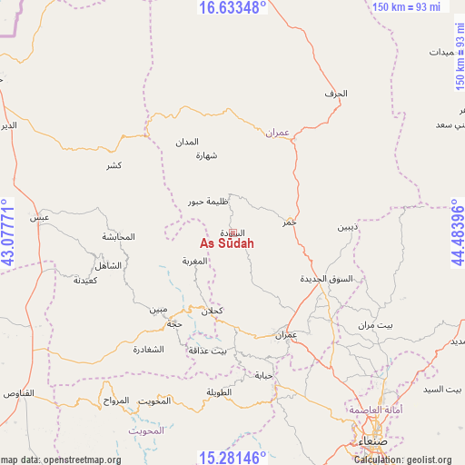
| Map corner | latitude | longitude |
|---|---|---|
| Upper-left | 16.63348°, | 43.07771° |
| Center: | 15.95861°, | 43.78083° |
| Lower-right: | 15.28146°, | 44.48396° |
| Map W x H: | 150.3×150.3 km | = 93.4×93.4mi |
| max Lat: | 17.76999° ⇑19.2% North |
| As Sūdah: | 15.95861° |
| min Lat: | ⇓80.8% South 12.18576° |
| min Long | As Sūdah | max Long |
| 42.67107° | 43.78083° | 54.01895° |
| W 26.3%⇐ | ⇒73.7% E |
Elevation
Elevation of As Sūdah is 2035 m = 6677 ft, and this is 730.2 m = 2396 ft above average elevation for this country.
| Max E: |
2791 m = 9157 ft | 24% |
| As Sūdah | 2035 m 6677 ft | |
| Avg. | 1304.8 m = 4281 ft | |
Min E: |
4 m = 13 ft | 76% |
See also: Yemen elevation on elevation.city.
Geographical zone
As Sūdah is located in North Torrid zone (between Equator and Tropic of Cancer). Distance of this Northern Tropic circle is 831.5 km =516.7 mi to North.| Distance of | km | miles | from As Sūdah |
|---|---|---|---|
| North Pole | 8232.6 | 5115.5 | to North |
| Arctic Circle | 5626.7 | 3496.3 | to North |
| Tropic Cancer | 831.5 | 516.7 | to North |
| Equator | 1774.4 | 1102.6 | to South |


Nearby cities:
15 places around As Sūdah: (largest is in red/bold)
• Al Jamīmah
20.8 km =12.9 mi,  288°
288°
• Al Madān
33 km =20.5 mi,  333°
333°
• Al Maghrabah
15.2 km =9.4 mi,  233°
233°
• Al Miftāḩ
33.9 km =21.1 mi,  272°
272°
• Al ‘Ashshah
34.1 km =21.2 mi,  13°
13°
• An Nāşirah
20.9 km =13 mi,  171°
171°
• As Sūq al Jadīd
33.5 km =20.8 mi,  116°
116°
• Aş Şarārah
20.6 km =12.8 mi,  152°
152°
• Khamir
18.8 km =11.7 mi,  79°
79°
• Kuḩlān ‘Affār
25.9 km =16.1 mi,  194°
194°
• Raydah
32.1 km =19.9 mi, 120°
• Shahārat al Ghīs
26.4 km =16.4 mi,  341°
341°
• Sharas
30.8 km =19.1 mi,  207°
207°
• Şuwayr
30.8 km =19.1 mi,  323°
323°
• Ḩabūr
13 km =8.1 mi, 322°
Sources, notices
• [Note1] Compared only with cities in Yemen existing in our database
• [Src1] Map data: © OpenStreetMap contributors (CC-BY-SA)
• [Src2] Other city data from geonames.org with taken over terms of usage.
• [Src3] Geographical zone / Annual Mean Temperature by Robert A. Rohde @ Wikipedia
