Raydah geodata
Raydah (Omran) is a seat of a second-order administrative division; located in Yemen in Asia/Aden (GMT+3) time zone. In our database, there are 51 cities with bigger population. Compared to other cities in Yemen, 76% of cities are located further ↓South; 62.7% of cities are located further →East and 84.7% of cities have lower elevation than Raydah. Note1


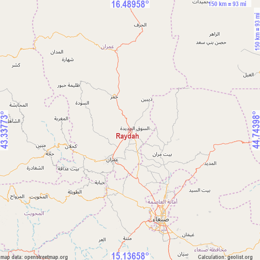
Raydah GPS coordinates[2]
15° 48' 51.156" North, 44° 2' 27.06" East
| Map corner | latitude | longitude |
|---|---|---|
| Upper-left | 16.48958°, | 43.33773° |
| Center: | 15.81421°, | 44.04085° |
| Lower-right: | 15.13658°, | 44.74398° |
| Map W x H: | 150.4×150.4 km | = 93.5×93.5mi |
| max Lat: | 17.76999° ⇑24% North |
| Raydah: | 15.81421° |
| min Lat: | ⇓76% South 12.18576° |
| min Long | Raydah | max Long |
| 42.67107° | 44.04085° | 54.01895° |
| W 37.3%⇐ | ⇒62.7% E |
Elevation
Elevation of Raydah is 2190 m = 7185 ft, and this is 885.2 m = 2904 ft above average elevation for this country.
| Max E: |
2791 m = 9157 ft | 15.3% |
| Raydah | 2190 m 7185 ft | |
| Avg. | 1304.8 m = 4281 ft | |
Min E: |
4 m = 13 ft | 84.7% |
See also: Yemen elevation on elevation.city.
Geographical zone
Raydah is located in North Torrid zone (between Equator and Tropic of Cancer). Distance of this Northern Tropic circle is 847.5 km =526.6 mi to North.| Distance of | km | miles | from Raydah |
|---|---|---|---|
| North Pole | 8248.7 | 5125.5 | to North |
| Arctic Circle | 5642.8 | 3506.3 | to North |
| Tropic Cancer | 847.5 | 526.6 | to North |
| Equator | 1758.4 | 1092.6 | to South |


Nearby cities:
15 places around Raydah: (largest is in red/bold)
• Al Khāniq
37.8 km =23.5 mi,  156°
156°
• Al Maghrabah
40.6 km =25.2 mi,  279°
279°
• Al Ḩayfah
22.9 km =14.2 mi,  112°
112°
• An Nāşirah
25.2 km =15.7 mi,  259°
259°
• As Sūdah
32.1 km =19.9 mi,  300°
300°
• As Sūq al Jadīd
2.6 km =1.6 mi,  62°
62°
• Aş Şarārah
18.4 km =11.4 mi, 263°
• Bayt Marrān
22.2 km =13.8 mi,  127°
127°
• Dhaybīn
20.4 km =12.7 mi,  27°
27°
• Khamir
21.4 km =13.3 mi,  334°
334°
• Kuḩlān ‘Affār
35.6 km =22.1 mi, 255°
• Saḩḩab
23.6 km =14.7 mi,  184°
184°
• Shibām
36.9 km =22.9 mi,  203°
203°
• Ḩabābah
34.8 km =21.6 mi,  210°
210°
• ‘Amrān
20.1 km =12.5 mi, 211°
Sources, notices
• [Note1] Compared only with cities in Yemen existing in our database
• [Src1] Map data: © OpenStreetMap contributors (CC-BY-SA)
• [Src2] Other city data from geonames.org with taken over terms of usage.
• [Src3] Geographical zone / Annual Mean Temperature by Robert A. Rohde @ Wikipedia
