Khamir geodata
Khamir (Omran) is a seat of a second-order administrative division; located in Yemen in Asia/Aden (GMT+3) time zone. In our database, there are 51 cities with bigger population. Compared to other cities in Yemen, 81.8% of cities are located further ↓South; 67.5% of cities are located further →East and 95.1% of cities have lower elevation than Khamir. Note1


Khamir GPS coordinates[2]
15° 59' 16.512" North, 43° 57' 13.032" East
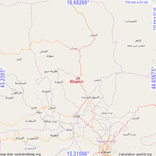
| Map corner | latitude | longitude |
|---|---|---|
| Upper-left | 16.66269°, | 43.2505° |
| Center: | 15.98792°, | 43.95362° |
| Lower-right: | 15.31086°, | 44.65675° |
| Map W x H: | 150.3×150.3 km | = 93.4×93.4mi |
| max Lat: | 17.76999° ⇑18.2% North |
| Khamir: | 15.98792° |
| min Lat: | ⇓81.8% South 12.18576° |
| min Long | Khamir | max Long |
| 42.67107° | 43.95362° | 54.01895° |
| W 32.5%⇐ | ⇒67.5% E |
Elevation
Elevation of Khamir is 2465 m = 8087 ft, and this is 1160.2 m = 3806 ft above average elevation for this country.
| Max E: |
2791 m = 9157 ft | 4.9% |
| Khamir | 2465 m 8087 ft | |
| Avg. | 1304.8 m = 4281 ft | |
Min E: |
4 m = 13 ft | 95.1% |
See also: Yemen elevation on elevation.city.
Geographical zone
Khamir is located in North Torrid zone (between Equator and Tropic of Cancer). Distance of this Northern Tropic circle is 828.2 km =514.6 mi to North.| Distance of | km | miles | from Khamir |
|---|---|---|---|
| North Pole | 8229.4 | 5113.5 | to North |
| Arctic Circle | 5623.5 | 3494.3 | to North |
| Tropic Cancer | 828.2 | 514.6 | to North |
| Equator | 1777.7 | 1104.6 | to South |


Nearby cities:
15 places around Khamir: (largest is in red/bold)
• Al Jamīmah
38.3 km =23.8 mi,  274°
274°
• Al Maghrabah
33.1 km =20.6 mi,  248°
248°
• Al Ḩayfah
41.4 km =25.7 mi,  132°
132°
• Al ‘Ashshah
31.7 km =19.7 mi,  340°
340°
• An Nāşirah
28.5 km =17.7 mi,  212°
212°
• As Sūdah
18.8 km =11.7 mi,  259°
259°
• As Sūq al Jadīd
21.5 km =13.4 mi,  147°
147°
• Aş Şarārah
23.3 km =14.5 mi,  202°
202°
• Dhaybīn
18.8 km =11.7 mi,  93°
93°
• Kuḩlān ‘Affār
37.8 km =23.5 mi,  221°
221°
• Raydah
21.4 km =13.3 mi, 154°
• Shahārat al Ghīs
34.6 km =21.5 mi,  309°
309°
• Ḩabūr
27.3 km =17 mi,  284°
284°
• Ḩūth
27.1 km =16.8 mi,  3°
3°
• ‘Amrān
36.5 km =22.7 mi,  181°
181°
Sources, notices
• [Note1] Compared only with cities in Yemen existing in our database
• [Src1] Map data: © OpenStreetMap contributors (CC-BY-SA)
• [Src2] Other city data from geonames.org with taken over terms of usage.
• [Src3] Geographical zone / Annual Mean Temperature by Robert A. Rohde @ Wikipedia
