Āl Ma‘ūdah geodata
Āl Ma‘ūdah (Al Bayda) is a seat of a second-order administrative division; located in Yemen in Asia/Aden (GMT+3) time zone. In our database, there are 51 cities with bigger population. Compared to other cities in Yemen, 69.5% of cities are located further ↑North; 73.7% of cities are located further ←West and 74.4% of cities have lower elevation than Āl Ma‘ūdah. Note1


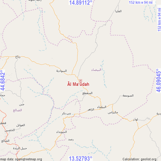
Āl Ma‘ūdah GPS coordinates[2]
14° 12' 37.98" North, 45° 23' 14.352" East
| Map corner | latitude | longitude |
|---|---|---|
| Upper-left | 14.89112°, | 44.6842° |
| Center: | 14.21055°, | 45.38732° |
| Lower-right: | 13.52793°, | 46.09045° |
| Map W x H: | 151.6×151.6 km | = 94.2×94.2mi |
| max Lat: | 17.76999° ⇑69.5% North |
| Āl Ma‘ūdah: | 14.21055° |
| min Lat: | ⇓30.5% South 12.18576° |
| min Long | Āl Ma‘ūdah | max Long |
| 42.67107° | 45.38732° | 54.01895° |
| W 73.7%⇐ | ⇒26.3% E |
Elevation
Elevation of Āl Ma‘ūdah is 2006 m = 6581 ft, and this is 701.2 m = 2301 ft above average elevation for this country.
| Max E: |
2791 m = 9157 ft | 25.6% |
| Āl Ma‘ūdah | 2006 m 6581 ft | |
| Avg. | 1304.8 m = 4281 ft | |
Min E: |
4 m = 13 ft | 74.4% |
See also: Yemen elevation on elevation.city.
Geographical zone
Āl Ma‘ūdah is located in North Torrid zone (between Equator and Tropic of Cancer). Distance of this Northern Tropic circle is 1025.9 km =637.5 mi to North.| Distance of | km | miles | from Āl Ma‘ūdah |
|---|---|---|---|
| North Pole | 8427 | 5236.3 | to North |
| Arctic Circle | 5821.1 | 3617.1 | to North |
| Tropic Cancer | 1025.9 | 637.5 | to North |
| Equator | 1580.1 | 981.8 | to South |


Nearby cities:
15 places around Āl Ma‘ūdah: (largest is in red/bold)
• Al Aqţa‘
50.4 km =31.3 mi,  355°
355°
• Al Bayda
32.1 km =19.9 mi,  141°
141°
• Al Ghaylah
47.8 km =29.7 mi,  26°
26°
• An Najd
25.4 km =15.8 mi,  337°
337°
• As Sawādīyah
20.5 km =12.7 mi,  299°
299°
• As Suwaydā
50.1 km =31.1 mi,  199°
199°
• Ash Sharyah
42.5 km =26.4 mi,  292°
292°
• Az Zāhir
29 km =18 mi,  159°
159°
• Aş Şawma‘ah
46.7 km =29 mi,  107°
107°
• Banī Bakr
33.5 km =20.8 mi, 202°
• Dhī Nā‘im
13.4 km =8.3 mi,  150°
150°
• Madīnat Lab‘ūs
41 km =25.5 mi, 201°
• Maswarah
39.4 km =24.5 mi,  67°
67°
• Mukayrās
42.6 km =26.5 mi,  134°
134°
• Sūq Sibāḩ
44.1 km =27.4 mi,  179°
179°
Sources, notices
• [Note1] Compared only with cities in Yemen existing in our database
• [Src1] Map data: © OpenStreetMap contributors (CC-BY-SA)
• [Src2] Other city data from geonames.org with taken over terms of usage.
• [Src3] Geographical zone / Annual Mean Temperature by Robert A. Rohde @ Wikipedia
