Al Ghaylah geodata
Al Ghaylah (Al Bayda) is a seat of a second-order administrative division; located in Yemen in Asia/Aden (GMT+3) time zone. In our database, there are 51 cities with bigger population. Compared to other cities in Yemen, 56.8% of cities are located further ↑North; 76% of cities are located further ←West and 64.3% of cities have lower elevation than Al Ghaylah. Note1


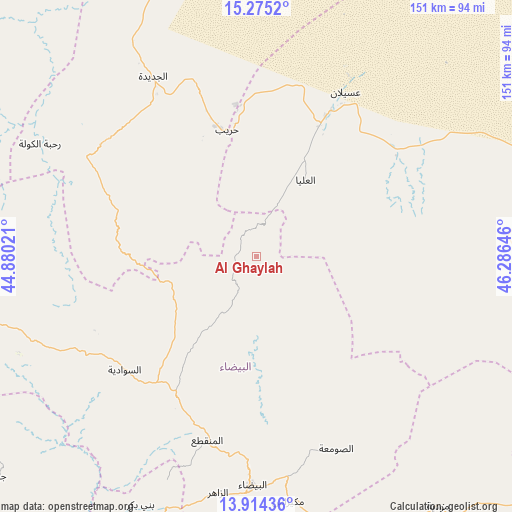
Al Ghaylah GPS coordinates[2]
14° 35' 44.988" North, 45° 34' 59.988" East
| Map corner | latitude | longitude |
|---|---|---|
| Upper-left | 15.2752°, | 44.88021° |
| Center: | 14.59583°, | 45.58333° |
| Lower-right: | 13.91436°, | 46.28646° |
| Map W x H: | 151.3×151.3 km | = 94×94mi |
| max Lat: | 17.76999° ⇑56.8% North |
| Al Ghaylah: | 14.59583° |
| min Lat: | ⇓43.2% South 12.18576° |
| min Long | Al Ghaylah | max Long |
| 42.67107° | 45.58333° | 54.01895° |
| W 76%⇐ | ⇒24% E |
Elevation
Elevation of Al Ghaylah is 1754 m = 5755 ft, and this is 449.2 m = 1474 ft above average elevation for this country.
| Max E: |
2791 m = 9157 ft | 35.7% |
| Al Ghaylah | 1754 m 5755 ft | |
| Avg. | 1304.8 m = 4281 ft | |
Min E: |
4 m = 13 ft | 64.3% |
See also: Yemen elevation on elevation.city.
Geographical zone
Al Ghaylah is located in North Torrid zone (between Equator and Tropic of Cancer). Distance of this Northern Tropic circle is 983 km =610.8 mi to North.| Distance of | km | miles | from Al Ghaylah |
|---|---|---|---|
| North Pole | 8384.2 | 5209.7 | to North |
| Arctic Circle | 5778.3 | 3590.5 | to North |
| Tropic Cancer | 983 | 610.8 | to North |
| Equator | 1622.9 | 1008.4 | to South |


Nearby cities:
15 places around Al Ghaylah: (largest is in red/bold)
• Al Aqţa‘
26 km =16.2 mi,  286°
286°
• Al Ḩajab
29.1 km =18.1 mi,  348°
348°
• Al Ḩazm
10.8 km =6.7 mi,  15°
15°
• Al ‘Amūd
42.8 km =26.6 mi, 288°
• Al ‘Āqir
35.5 km =22.1 mi,  94°
94°
• An Najd
36.5 km =22.7 mi,  237°
237°
• As Sawādīyah
50.9 km =31.6 mi,  229°
229°
• Aş Şawma‘ah
61.4 km =38.2 mi,  157°
157°
• Bayḩān
27 km =16.8 mi,  32°
32°
• Dhī Nā‘im
56.4 km =35 mi,  194°
194°
• Judaydah
61.4 km =38.2 mi,  330°
330°
• Maswarah
32 km =19.9 mi,  151°
151°
• Āl Ma‘ūdah
47.8 km =29.7 mi,  206°
206°
• Ḩarīb
38.3 km =23.8 mi, 347°
• ‘Usaylān
55.2 km =34.3 mi, 28°
Sources, notices
• [Note1] Compared only with cities in Yemen existing in our database
• [Src1] Map data: © OpenStreetMap contributors (CC-BY-SA)
• [Src2] Other city data from geonames.org with taken over terms of usage.
• [Src3] Geographical zone / Annual Mean Temperature by Robert A. Rohde @ Wikipedia
