Al Hijrah geodata
Al Hijrah (Şa‘dah) is a seat of a second-order administrative division; located in Yemen in Asia/Aden (GMT+3) time zone. In our database, there are 51 cities with bigger population. Compared to other cities in Yemen, 98.7% of cities are located further ↓South; 89.9% of cities are located further →East and 94.2% of cities have lower elevation than Al Hijrah. Note1


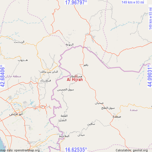
Al Hijrah GPS coordinates[2]
17° 17' 52.368" North, 43° 23' 13.848" East
| Map corner | latitude | longitude |
|---|---|---|
| Upper-left | 17.96797°, | 42.68406° |
| Center: | 17.29788°, | 43.38718° |
| Lower-right: | 16.62535°, | 44.09031° |
| Map W x H: | 149.3×149.3 km | = 92.8×92.8mi |
| max Lat: | 17.76999° ⇑1.3% North |
| Al Hijrah: | 17.29788° |
| min Lat: | ⇓98.7% South 12.18576° |
| min Long | Al Hijrah | max Long |
| 42.67107° | 43.38718° | 54.01895° |
| W 10.1%⇐ | ⇒89.9% E |
Elevation
Elevation of Al Hijrah is 2449 m = 8035 ft, and this is 1144.2 m = 3754 ft above average elevation for this country.
| Max E: |
2791 m = 9157 ft | 5.8% |
| Al Hijrah | 2449 m 8035 ft | |
| Avg. | 1304.8 m = 4281 ft | |
Min E: |
4 m = 13 ft | 94.2% |
See also: Yemen elevation on elevation.city.
Geographical zone
Al Hijrah is located in North Torrid zone (between Equator and Tropic of Cancer). Distance of this Northern Tropic circle is 682.6 km =424.1 mi to North.| Distance of | km | miles | from Al Hijrah |
|---|---|---|---|
| North Pole | 8083.7 | 5023 | to North |
| Arctic Circle | 5477.8 | 3403.7 | to North |
| Tropic Cancer | 682.6 | 424.1 | to North |
| Equator | 1923.3 | 1195.1 | to South |


Nearby cities:
15 places around Al Hijrah: (largest is in red/bold)
• Al Kharāb
34.5 km =21.4 mi,  188°
188°
• Al Malāḩīţ
60 km =37.3 mi, 191°
• Al Mashāf
52.9 km =32.9 mi,  202°
202°
• Al Ḩashwah
104 km =64.6 mi,  114°
114°
• An Naz̧īr
45.2 km =28.1 mi, 197°
• Ash Shawātī
72.9 km =45.3 mi,  141°
141°
• Bāqim as Sūq
14.6 km =9.1 mi,  40°
40°
• Kitāf
82.2 km =51.1 mi, 111°
• Majz
32.3 km =20.1 mi, 141°
• Sa'dah
56.4 km =35 mi,  134°
134°
• Sāqayn
49 km =30.4 mi,  162°
162°
• Sūq al Khamīs
16.7 km =10.4 mi,  219°
219°
• Washḩah
110.1 km =68.4 mi,  178°
178°
• Ḩaraḑ
104.8 km =65.1 mi, 199°
• Ḩaydān
57.9 km =36 mi, 175°
Sources, notices
• [Note1] Compared only with cities in Yemen existing in our database
• [Src1] Map data: © OpenStreetMap contributors (CC-BY-SA)
• [Src2] Other city data from geonames.org with taken over terms of usage.
• [Src3] Geographical zone / Annual Mean Temperature by Robert A. Rohde @ Wikipedia
