Kitāf geodata
Kitāf (Şa‘dah) is a seat of a second-order administrative division; located in Yemen in Asia/Aden (GMT+3) time zone. In our database, there are 51 cities with bigger population. Compared to other cities in Yemen, 97.4% of cities are located further ↓South; 61% of cities are located further →East and 70.5% of cities have lower elevation than Kitāf. Note1


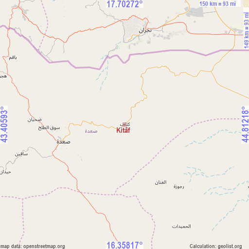
Kitāf GPS coordinates[2]
17° 1' 53.94" North, 44° 6' 32.58" East
| Map corner | latitude | longitude |
|---|---|---|
| Upper-left | 17.70272°, | 43.40593° |
| Center: | 17.03165°, | 44.10905° |
| Lower-right: | 16.35817°, | 44.81218° |
| Map W x H: | 149.5×149.5 km | = 92.9×92.9mi |
| max Lat: | 17.76999° ⇑2.6% North |
| Kitāf: | 17.03165° |
| min Lat: | ⇓97.4% South 12.18576° |
| min Long | Kitāf | max Long |
| 42.67107° | 44.10905° | 54.01895° |
| W 39%⇐ | ⇒61% E |
Elevation
Elevation of Kitāf is 1953 m = 6407 ft, and this is 648.2 m = 2127 ft above average elevation for this country.
| Max E: |
2791 m = 9157 ft | 29.5% |
| Kitāf | 1953 m 6407 ft | |
| Avg. | 1304.8 m = 4281 ft | |
Min E: |
4 m = 13 ft | 70.5% |
See also: Yemen elevation on elevation.city.
Geographical zone
Kitāf is located in North Torrid zone (between Equator and Tropic of Cancer). Distance of this Northern Tropic circle is 712.2 km =442.5 mi to North.| Distance of | km | miles | from Kitāf |
|---|---|---|---|
| North Pole | 8113.3 | 5041.4 | to North |
| Arctic Circle | 5507.4 | 3422.1 | to North |
| Tropic Cancer | 712.2 | 442.5 | to North |
| Equator | 1893.7 | 1176.7 | to South |


Nearby cities:
15 places around Kitāf: (largest is in red/bold)
• Al Hijrah
82.2 km =51.1 mi,  291°
291°
• Al Kharāb
82 km =51 mi,  266°
266°
• Al Khirāb
56.5 km =35.1 mi,  160°
160°
• Al Maḩjal
86.3 km =53.6 mi,  114°
114°
• Al Ḩarf
74.3 km =46.2 mi,  181°
181°
• Al Ḩashwah
22.6 km =14 mi,  128°
128°
• Al Ḩumaydāt
69.8 km =43.4 mi,  150°
150°
• Al ‘Inān
40.7 km =25.3 mi, 147°
• Ash Shawātī
41.9 km =26 mi,  228°
228°
• Bāqim as Sūq
78.4 km =48.7 mi,  301°
301°
• Majz
56.9 km =35.4 mi, 274°
• Rajūzah
49.1 km =30.5 mi,  138°
138°
• Sa'dah
38.1 km =23.7 mi,  254°
254°
• Sāqayn
64.5 km =40.1 mi, 254°
• Ḩaydān
77.1 km =47.9 mi, 248°
Sources, notices
• [Note1] Compared only with cities in Yemen existing in our database
• [Src1] Map data: © OpenStreetMap contributors (CC-BY-SA)
• [Src2] Other city data from geonames.org with taken over terms of usage.
• [Src3] Geographical zone / Annual Mean Temperature by Robert A. Rohde @ Wikipedia
