Ḩaydān geodata
Ḩaydān (Şa‘dah) is a seat of a second-order administrative division; located in Yemen in Asia/Aden (GMT+3) time zone. In our database, there are 51 cities with bigger population. Compared to other cities in Yemen, 94.5% of cities are located further ↓South; 87.3% of cities are located further →East and 80.2% of cities have lower elevation than Ḩaydān. Note1


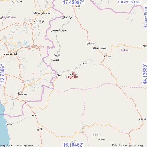
Ḩaydān GPS coordinates[2]
16° 46' 44.364" North, 43° 26' 1.392" East
| Map corner | latitude | longitude |
|---|---|---|
| Upper-left | 17.45097°, | 42.7306° |
| Center: | 16.77899°, | 43.43372° |
| Lower-right: | 16.10462°, | 44.13685° |
| Map W x H: | 149.7×149.7 km | = 93×93mi |
| max Lat: | 17.76999° ⇑5.5% North |
| Ḩaydān: | 16.77899° |
| min Lat: | ⇓94.5% South 12.18576° |
| min Long | Ḩaydān | max Long |
| 42.67107° | 43.43372° | 54.01895° |
| W 12.7%⇐ | ⇒87.3% E |
Elevation
Elevation of Ḩaydān is 2121 m = 6959 ft, and this is 816.2 m = 2678 ft above average elevation for this country.
| Max E: |
2791 m = 9157 ft | 19.8% |
| Ḩaydān | 2121 m 6959 ft | |
| Avg. | 1304.8 m = 4281 ft | |
Min E: |
4 m = 13 ft | 80.2% |
See also: Yemen elevation on elevation.city.
Geographical zone
Ḩaydān is located in North Torrid zone (between Equator and Tropic of Cancer). Distance of this Northern Tropic circle is 740.3 km =460 mi to North.| Distance of | km | miles | from Ḩaydān |
|---|---|---|---|
| North Pole | 8141.4 | 5058.8 | to North |
| Arctic Circle | 5535.5 | 3439.6 | to North |
| Tropic Cancer | 740.3 | 460 | to North |
| Equator | 1865.6 | 1159.2 | to South |


Nearby cities:
15 places around Ḩaydān: (largest is in red/bold)
• Al Hijrah
57.9 km =36 mi,  355°
355°
• Al Kharāb
25.7 km =16 mi,  336°
336°
• Al Madān
65.6 km =40.8 mi,  160°
160°
• Al Malāḩīţ
16.9 km =10.5 mi,  266°
266°
• Al Mashāf
26.6 km =16.5 mi,  289°
289°
• Al Qaflah
62.3 km =38.7 mi,  145°
145°
• An Naz̧īr
23.3 km =14.5 mi,  308°
308°
• Ash Shawātī
40.3 km =25 mi,  89°
89°
• Majz
35.6 km =22.1 mi,  24°
24°
• Mustabā’
64.3 km =40 mi,  197°
197°
• Sa'dah
39.4 km =24.5 mi,  62°
62°
• Sāqayn
14.6 km =9.1 mi,  41°
41°
• Sūq al Khamīs
47.3 km =29.4 mi, 340°
• Washḩah
52.5 km =32.6 mi,  182°
182°
• Ḩaraḑ
57.3 km =35.6 mi,  224°
224°
Sources, notices
• [Note1] Compared only with cities in Yemen existing in our database
• [Src1] Map data: © OpenStreetMap contributors (CC-BY-SA)
• [Src2] Other city data from geonames.org with taken over terms of usage.
• [Src3] Geographical zone / Annual Mean Temperature by Robert A. Rohde @ Wikipedia
