Al-Medy Village, قرية المدي geodata
Al-Medy Village, قرية المدي (Dhamār) is a farm village; located in Yemen in Asia/Aden (GMT+3) time zone. With population of 2,000 people, there are 33 cities with bigger population in this country. Compared to other cities in Yemen, 63% of cities are located further ↑North; 72.7% of cities are located further →East and 77.6% of cities have lower elevation than Al-Medy Village, قرية المدي. Note1
Current local time in Al-Medy Village, قرية المدي:
02:00 AM, WednesdayDifference from your time zone: hours


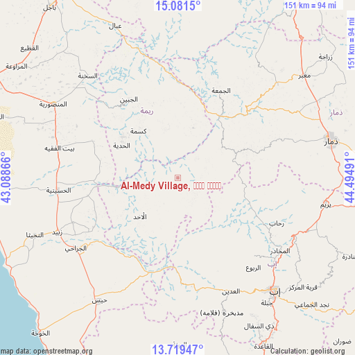
Al-Medy Village, قرية المدي GPS coordinates[2]
14° 24' 5.472" North, 43° 47' 30.408" East
| Map corner | latitude | longitude |
|---|---|---|
| Upper-left | 15.0815°, | 43.08866° |
| Center: | 14.40152°, | 43.79178° |
| Lower-right: | 13.71947°, | 44.49491° |
| Map W x H: | 151.4×151.4 km | = 94.1×94.1mi |
| max Lat: | 17.76999° ⇑63% North |
| Al-Medy Village, قرية المدي: | 14.40152° |
| min Lat: | ⇓37% South 12.18576° |
| min Long | Al-Medy Village | max Long |
| 42.67107° | 43.79178° | 54.01895° |
| W 27.3%⇐ | ⇒72.7% E |
Elevation
Elevation of Al-Medy Village, قرية المدي is 2063 m = 6768 ft, and this is 758.2 m = 2488 ft above average elevation for this country.
| Max E: |
2791 m = 9157 ft | 22.4% |
| Al-Medy Village, قرية المدي | 2063 m 6768 ft | |
| Avg. | 1304.8 m = 4281 ft | |
Min E: |
4 m = 13 ft | 77.6% |
See also: Yemen elevation on elevation.city.
Geographical zone
Al-Medy Village, قرية المدي is located in North Torrid zone (between Equator and Tropic of Cancer). Distance of this Northern Tropic circle is 1004.6 km =624.2 mi to North.| Distance of | km | miles | from Al-Medy Village, قرية المدي |
|---|---|---|---|
| North Pole | 8405.8 | 5223.1 | to North |
| Arctic Circle | 5799.9 | 3603.9 | to North |
| Tropic Cancer | 1004.6 | 624.2 | to North |
| Equator | 1601.3 | 995 | to South |


Nearby cities:
15 places around Al-Medy Village, قرية المدي: (largest is in red/bold)
• Ad Dann
8.6 km =5.3 mi,  130°
130°
• Al Aḩad
22.7 km =14.1 mi,  225°
225°
• Al Jabīn
39.5 km =24.5 mi,  328°
328°
• Al Jum‘ah
41.8 km =26 mi,  26°
26°
• Al Ḩadīyah
27.6 km =17.1 mi,  300°
300°
• Ar Ramādī
49.5 km =30.8 mi,  180°
180°
• Aḑ Ḑil‘
30.2 km =18.8 mi,  5°
5°
• Kusmah
26.1 km =16.2 mi,  320°
320°
• Markaz al Marīr
51.2 km =31.8 mi,  204°
204°
• Riḩāb
46.9 km =29.1 mi,  114°
114°
• Sūq ar Rubū‘
27 km =16.8 mi,  63°
63°
• Z̧almah al ‘Ulyā
46.6 km =29 mi,  135°
135°
• Ḑubāh
37.9 km =23.5 mi,  74°
74°
• Ḩammām ‘Alī
48.1 km =29.9 mi,  52°
52°
• Ḩazm al ‘Udayn
47.5 km =29.5 mi,  151°
151°
Sources, notices
• [Note1] Compared only with cities in Yemen existing in our database
• [Src1] Map data: © OpenStreetMap contributors (CC-BY-SA)
• [Src2] Other city data from geonames.org with taken over terms of usage.
• [Src3] Geographical zone / Annual Mean Temperature by Robert A. Rohde @ Wikipedia
