Al Aḩad geodata
Al Aḩad (Dhamār) is a seat of a second-order administrative division; located in Yemen in Asia/Aden (GMT+3) time zone. In our database, there are 51 cities with bigger population. Compared to other cities in Yemen, 68.2% of cities are located further ↑North; 78.6% of cities are located further →East and 54.2% of cities have higher elevation than Al Aḩad. Note1


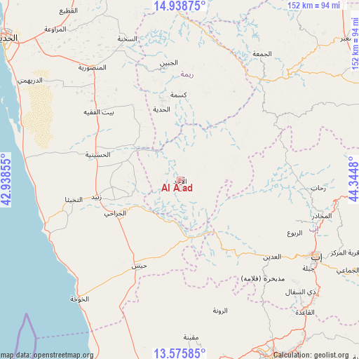
Al Aḩad GPS coordinates[2]
14° 15' 29.988" North, 43° 38' 30.012" East
| Map corner | latitude | longitude |
|---|---|---|
| Upper-left | 14.93875°, | 42.93855° |
| Center: | 14.25833°, | 43.64167° |
| Lower-right: | 13.57585°, | 44.3448° |
| Map W x H: | 151.5×151.5 km | = 94.1×94.1mi |
| max Lat: | 17.76999° ⇑68.2% North |
| Al Aḩad: | 14.25833° |
| min Lat: | ⇓31.8% South 12.18576° |
| min Long | Al Aḩad | max Long |
| 42.67107° | 43.64167° | 54.01895° |
| W 21.4%⇐ | ⇒78.6% E |
Elevation
Elevation of Al Aḩad is 1240 m = 4068 ft, and this is 64.8 m = 213 ft below average elevation for this country.
| Max E: |
2791 m = 9157 ft | 54.2% |
| Avg. | 1304.8 m = 4281 ft | |
| Al Aḩad | 1240 m = 4068 ft | |
Min E: |
4 m = 13 ft | 45.8% |
See also: Yemen elevation on elevation.city.
Geographical zone
Al Aḩad is located in North Torrid zone (between Equator and Tropic of Cancer). Distance of this Northern Tropic circle is 1020.5 km =634.1 mi to North.| Distance of | km | miles | from Al Aḩad |
|---|---|---|---|
| North Pole | 8421.7 | 5233 | to North |
| Arctic Circle | 5815.8 | 3613.8 | to North |
| Tropic Cancer | 1020.5 | 634.1 | to North |
| Equator | 1585.4 | 985.1 | to South |


Nearby cities:
15 places around Al Aḩad: (largest is in red/bold)
• Ad Dann
25 km =15.5 mi,  65°
65°
• Al Jabīn
49.8 km =30.9 mi,  354°
354°
• Al Jarrāḩī
30.7 km =19.1 mi,  242°
242°
• Al Ḩadīyah
30.8 km =19.1 mi, 345°
• Al-Medy Village, قرية المدي
22.7 km =14.1 mi,  45°
45°
• Ar Ramādī
36.9 km =22.9 mi,  155°
155°
• At Tuḩaytā’
45.5 km =28.3 mi,  259°
259°
• Aḑ Ḑil‘
49.8 km =30.9 mi,  22°
22°
• Bayt al Faqīh
44.6 km =27.7 mi,  310°
310°
• Kusmah
36 km =22.4 mi,  359°
359°
• Markaz al Marīr
31.2 km =19.4 mi,  189°
189°
• Sūq ar Rubū‘
49.1 km =30.5 mi,  55°
55°
• Zabīd
35.9 km =22.3 mi, 258°
• Ḩays
40.1 km =24.9 mi,  205°
205°
• Ḩazm al ‘Udayn
46.9 km =29.1 mi,  123°
123°
Sources, notices
• [Note1] Compared only with cities in Yemen existing in our database
• [Src1] Map data: © OpenStreetMap contributors (CC-BY-SA)
• [Src2] Other city data from geonames.org with taken over terms of usage.
• [Src3] Geographical zone / Annual Mean Temperature by Robert A. Rohde @ Wikipedia
