Mabyan geodata
Mabyan (Ḩajjah) is a seat of a second-order administrative division; located in Yemen in Asia/Aden (GMT+3) time zone. In our database, there are 51 cities with bigger population. Compared to other cities in Yemen, 74.7% of cities are located further ↓South; 82.1% of cities are located further →East and 67.5% of cities have lower elevation than Mabyan. Note1


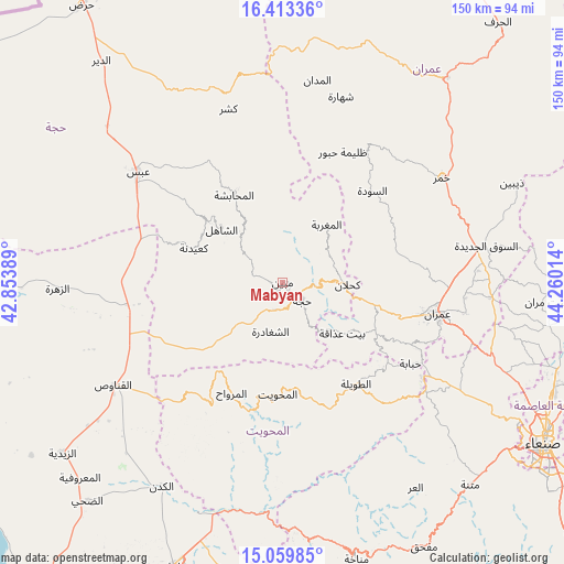
Mabyan GPS coordinates[2]
15° 44' 15.828" North, 43° 33' 25.236" East
| Map corner | latitude | longitude |
|---|---|---|
| Upper-left | 16.41336°, | 42.85389° |
| Center: | 15.73773°, | 43.55701° |
| Lower-right: | 15.05985°, | 44.26014° |
| Map W x H: | 150.5×150.5 km | = 93.5×93.5mi |
| max Lat: | 17.76999° ⇑25.3% North |
| Mabyan: | 15.73773° |
| min Lat: | ⇓74.7% South 12.18576° |
| min Long | Mabyan | max Long |
| 42.67107° | 43.55701° | 54.01895° |
| W 17.9%⇐ | ⇒82.1% E |
Elevation
Elevation of Mabyan is 1870 m = 6135 ft, and this is 565.2 m = 1854 ft above average elevation for this country.
| Max E: |
2791 m = 9157 ft | 32.5% |
| Mabyan | 1870 m 6135 ft | |
| Avg. | 1304.8 m = 4281 ft | |
Min E: |
4 m = 13 ft | 67.5% |
See also: Yemen elevation on elevation.city.
Geographical zone
Mabyan is located in North Torrid zone (between Equator and Tropic of Cancer). Distance of this Northern Tropic circle is 856 km =531.9 mi to North.| Distance of | km | miles | from Mabyan |
|---|---|---|---|
| North Pole | 8257.2 | 5130.8 | to North |
| Arctic Circle | 5651.3 | 3511.6 | to North |
| Tropic Cancer | 856 | 531.9 | to North |
| Equator | 1749.9 | 1087.3 | to South |


Nearby cities:
15 places around Mabyan: (largest is in red/bold)
• Al Maghrabah
19.4 km =12.1 mi,  37°
37°
• Al Maḩābishah
26.7 km =16.6 mi,  330°
330°
• Al Miftāḩ
28.1 km =17.5 mi,  339°
339°
• An Nāşirah
27.2 km =16.9 mi,  81°
81°
• Ash Shaghādirah
13.7 km =8.5 mi,  196°
196°
• Ash Shāhil
21.7 km =13.5 mi,  311°
311°
• Banī al ‘Awwām
17.7 km =11 mi,  169°
169°
• Banī an Nahārī
10.9 km =6.8 mi,  180°
180°
• Bayt ‘Adhāqah
20.6 km =12.8 mi,  131°
131°
• Kuḩlān ‘Affār
17.3 km =10.7 mi,  91°
91°
• Ku‘aydinah
25.3 km =15.7 mi,  291°
291°
• Sharas
10.3 km =6.4 mi,  105°
105°
• Sūq Shamar
26 km =16.2 mi, 309°
• Waḑarah
8.4 km =5.2 mi,  249°
249°
• Ḩajjah
7.1 km =4.4 mi, 132°
Sources, notices
• [Note1] Compared only with cities in Yemen existing in our database
• [Src1] Map data: © OpenStreetMap contributors (CC-BY-SA)
• [Src2] Other city data from geonames.org with taken over terms of usage.
• [Src3] Geographical zone / Annual Mean Temperature by Robert A. Rohde @ Wikipedia
