Al Qaflah geodata
Al Qaflah (Omran) is a seat of a second-order administrative division; located in Yemen in Asia/Aden (GMT+3) time zone. In our database, there are 51 cities with bigger population. Compared to other cities in Yemen, 90.3% of cities are located further ↓South; 74% of cities are located further →East and 50.3% of cities have higher elevation than Al Qaflah. Note1


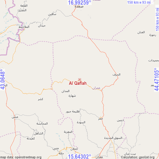
Al Qaflah GPS coordinates[2]
16° 19' 8.292" North, 43° 46' 4.512" East
| Map corner | latitude | longitude |
|---|---|---|
| Upper-left | 16.99259°, | 43.0648° |
| Center: | 16.31897°, | 43.76792° |
| Lower-right: | 15.64302°, | 44.47105° |
| Map W x H: | 150.1×150.1 km | = 93.3×93.3mi |
| max Lat: | 17.76999° ⇑9.7% North |
| Al Qaflah: | 16.31897° |
| min Lat: | ⇓90.3% South 12.18576° |
| min Long | Al Qaflah | max Long |
| 42.67107° | 43.76792° | 54.01895° |
| W 26%⇐ | ⇒74% E |
Elevation
Elevation of Al Qaflah is 1305 m = 4281 ft, and this is 0.20000000000005 m = 1 ft above average elevation for this country.
| Max E: |
2791 m = 9157 ft | 50.3% |
| Al Qaflah | 1305 m 4281 ft | |
| Avg. | 1304.8 m = 4281 ft | |
Min E: |
4 m = 13 ft | 49.7% |
See also: Yemen elevation on elevation.city.
Geographical zone
Al Qaflah is located in North Torrid zone (between Equator and Tropic of Cancer). Distance of this Northern Tropic circle is 791.4 km =491.8 mi to North.| Distance of | km | miles | from Al Qaflah |
|---|---|---|---|
| North Pole | 8192.6 | 5090.6 | to North |
| Arctic Circle | 5586.7 | 3471.4 | to North |
| Tropic Cancer | 791.4 | 491.8 | to North |
| Equator | 1814.5 | 1127.5 | to South |


Nearby cities:
15 places around Al Qaflah: (largest is in red/bold)
• Al Jamīmah
38.2 km =23.7 mi,  208°
208°
• Al Madān
16.9 km =10.5 mi,  231°
231°
• Al Maghrabah
50.3 km =31.3 mi,  192°
192°
• Al Miftāḩ
50.2 km =31.2 mi,  220°
220°
• Al Ḩarf
35.2 km =21.9 mi,  81°
81°
• Al ‘Ashshah
11.6 km =7.2 mi,  126°
126°
• As Sūdah
40.1 km =24.9 mi,  178°
178°
• Ash Shawātī
51.8 km =32.2 mi,  5°
5°
• Khamir
41.8 km =26 mi,  151°
151°
• Kushar
41.3 km =25.7 mi,  243°
243°
• Shahārat al Ghīs
16.6 km =10.3 mi, 205°
• Washḩah
38.1 km =23.7 mi,  268°
268°
• Şuwayr
22.7 km =14.1 mi, 227°
• Ḩabūr
30.5 km =19 mi, 192°
• Ḩūth
23.5 km =14.6 mi,  114°
114°
Sources, notices
• [Note1] Compared only with cities in Yemen existing in our database
• [Src1] Map data: © OpenStreetMap contributors (CC-BY-SA)
• [Src2] Other city data from geonames.org with taken over terms of usage.
• [Src3] Geographical zone / Annual Mean Temperature by Robert A. Rohde @ Wikipedia
