Zabīd geodata
Zabīd (Al Hudaydah) is a seat of a second-order administrative division; located in Yemen in Asia/Aden (GMT+3) time zone. With population of 52,590 people, there are 9 cities with bigger population in this country. Compared to other cities in Yemen, 70.1% of cities are located further ↑North; 92.5% of cities are located further →East and 87% of cities have higher elevation than Zabīd. Note1


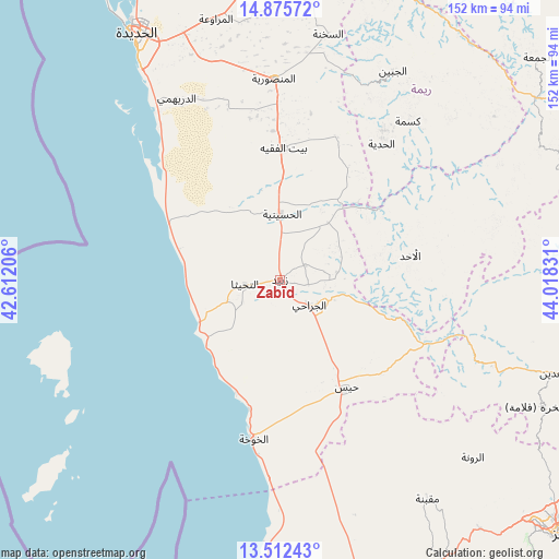
Zabīd GPS coordinates[2]
14° 11' 42.36" North, 43° 18' 54.648" East
| Map corner | latitude | longitude |
|---|---|---|
| Upper-left | 14.87572°, | 42.61206° |
| Center: | 14.1951°, | 43.31518° |
| Lower-right: | 13.51243°, | 44.01831° |
| Map W x H: | 151.6×151.6 km | = 94.2×94.2mi |
| max Lat: | 17.76999° ⇑70.1% North |
| Zabīd: | 14.1951° |
| min Lat: | ⇓29.9% South 12.18576° |
| min Long | Zabīd | max Long |
| 42.67107° | 43.31518° | 54.01895° |
| W 7.5%⇐ | ⇒92.5% E |
Elevation
Elevation of Zabīd is 114 m = 374 ft, and this is 1190.8 m = 3907 ft below average elevation for this country.
| Max E: |
2791 m = 9157 ft | 87% |
| Avg. | 1304.8 m = 4281 ft | |
| Zabīd | 114 m = 374 ft | |
Min E: |
4 m = 13 ft | 13% |
See also: Zabīd elevation on elevation.city.
Geographical zone
Zabīd is located in North Torrid zone (between Equator and Tropic of Cancer). Distance of this Northern Tropic circle is 1027.6 km =638.5 mi to North.| Distance of | km | miles | from Zabīd |
|---|---|---|---|
| North Pole | 8428.7 | 5237.3 | to North |
| Arctic Circle | 5822.8 | 3618.1 | to North |
| Tropic Cancer | 1027.6 | 638.5 | to North |
| Equator | 1578.3 | 980.7 | to South |


Nearby cities:
15 places around Zabīd: (largest is in red/bold)
• Ad Dann
60.5 km =37.6 mi,  73°
73°
• Ad Durayhimī
56.6 km =35.2 mi,  330°
330°
• Al Aḩad
35.9 km =22.3 mi,  78°
78°
• Al Jabīn
64.3 km =40 mi,  28°
28°
• Al Jarrāḩī
10.5 km =6.5 mi,  131°
131°
• Al Khawkhah
43.7 km =27.2 mi,  189°
189°
• Al Manşūrīyah
54.6 km =33.9 mi,  358°
358°
• Al Ḩadīyah
46 km =28.6 mi,  36°
36°
• Al-Medy Village, قرية المدي
56.2 km =34.9 mi, 65°
• Ar Ramādī
57.2 km =35.5 mi,  117°
117°
• At Tuḩaytā’
9.7 km =6 mi,  262°
262°
• Bayt al Faqīh
35.7 km =22.2 mi,  1°
1°
• Kusmah
55.2 km =34.3 mi, 38°
• Markaz al Marīr
38.4 km =23.9 mi, 128°
• Ḩays
34.4 km =21.4 mi,  148°
148°
Sources, notices
• [Note1] Compared only with cities in Yemen existing in our database
• [Src1] Map data: © OpenStreetMap contributors (CC-BY-SA)
• [Src2] Other city data from geonames.org with taken over terms of usage.
• [Src3] Geographical zone / Annual Mean Temperature by Robert A. Rohde @ Wikipedia
