Ḩays geodata
Ḩays (Al Hudaydah) is a seat of a second-order administrative division; located in Yemen in Asia/Aden (GMT+3) time zone. In our database, there are 51 cities with bigger population. Compared to other cities in Yemen, 77.9% of cities are located further ↑North; 85.4% of cities are located further →East and 83.8% of cities have higher elevation than Ḩays. Note1


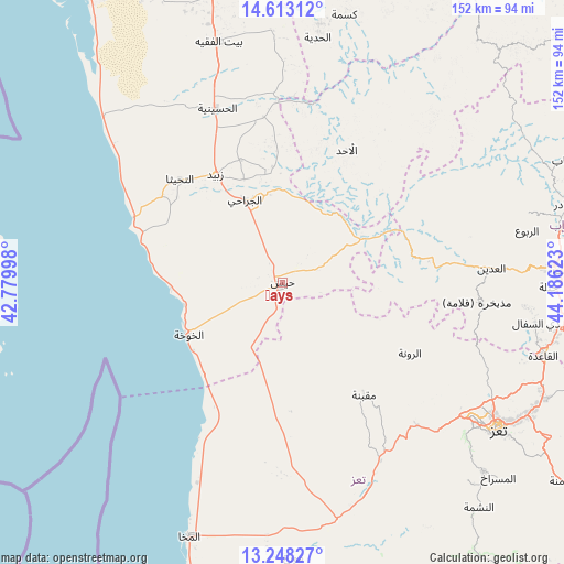
Ḩays GPS coordinates[2]
13° 55' 54.12" North, 43° 28' 59.16" East
| Map corner | latitude | longitude |
|---|---|---|
| Upper-left | 14.61312°, | 42.77998° |
| Center: | 13.9317°, | 43.4831° |
| Lower-right: | 13.24827°, | 44.18623° |
| Map W x H: | 151.8×151.8 km | = 94.3×94.3mi |
| max Lat: | 17.76999° ⇑77.9% North |
| Ḩays: | 13.9317° |
| min Lat: | ⇓22.1% South 12.18576° |
| min Long | Ḩays | max Long |
| 42.67107° | 43.4831° | 54.01895° |
| W 14.6%⇐ | ⇒85.4% E |
Elevation
Elevation of Ḩays is 211 m = 692 ft, and this is 1093.8 m = 3589 ft below average elevation for this country.
| Max E: |
2791 m = 9157 ft | 83.8% |
| Avg. | 1304.8 m = 4281 ft | |
| Ḩays | 211 m = 692 ft | |
Min E: |
4 m = 13 ft | 16.2% |
See also: Yemen elevation on elevation.city.
Geographical zone
Ḩays is located in North Torrid zone (between Equator and Tropic of Cancer). Distance of this Northern Tropic circle is 1056.9 km =656.7 mi to North.| Distance of | km | miles | from Ḩays |
|---|---|---|---|
| North Pole | 8458 | 5255.6 | to North |
| Arctic Circle | 5852.1 | 3636.3 | to North |
| Tropic Cancer | 1056.9 | 656.7 | to North |
| Equator | 1549.1 | 962.6 | to South |


Nearby cities:
15 places around Ḩays: (largest is in red/bold)
• Al Aḩad
40.1 km =24.9 mi,  25°
25°
• Al Jarrāḩī
24.6 km =15.3 mi,  335°
335°
• Al Khawkhah
28.8 km =17.9 mi,  241°
241°
• Al ‘Udayn
55.6 km =34.5 mi,  85°
85°
• Ar Ramādī
32.6 km =20.3 mi, 85°
• Ar Rawnah
39.6 km =24.6 mi,  119°
119°
• Ar Rubū‘
44.9 km =27.9 mi,  112°
112°
• At Tuḩaytā’
39.4 km =24.5 mi,  315°
315°
• Maqbanah
37 km =23 mi,  143°
143°
• Markaz Mudhaykirah
52.6 km =32.7 mi,  95°
95°
• Markaz al Marīr
13.3 km =8.3 mi,  65°
65°
• Qaryat Al kudshi al Ra'inah
49.8 km =30.9 mi, 122°
• Village of ALAMRAH
33.9 km =21.1 mi,  128°
128°
• Zabīd
34.4 km =21.4 mi,  328°
328°
• Ḩazm al ‘Udayn
57.3 km =35.6 mi,  79°
79°
Sources, notices
• [Note1] Compared only with cities in Yemen existing in our database
• [Src1] Map data: © OpenStreetMap contributors (CC-BY-SA)
• [Src2] Other city data from geonames.org with taken over terms of usage.
• [Src3] Geographical zone / Annual Mean Temperature by Robert A. Rohde @ Wikipedia
