Pretoria geodata
Pretoria (Gauteng) is a capital of a political entity; located in South Africa in Africa/Johannesburg (GMT+2) time zone. With population of 1,619,438 people, there are 4 cities with bigger population in this country. Compared to other cities in South Africa, 87% of cities are located further ↓South; 60.8% of cities are located further ←West and 67.8% of cities have lower elevation than Pretoria. Note1
Administrative division(s):
- Level 1: Gauteng
- Level 2: City of Tshwane Metropolitan Municipality
- Level 3: City of Tshwane


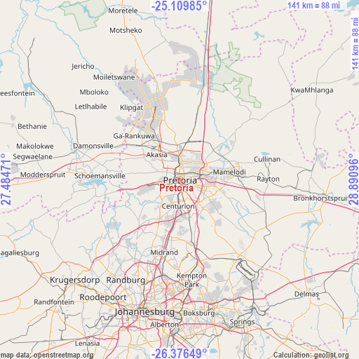
Pretoria GPS coordinates[2]
25° 44' 41.496" South, 28° 11' 16.188" East
| Map corner | latitude | longitude |
|---|---|---|
| Upper-left | -25.10985°, | 27.48471° |
| Center: | -25.74486°, | 28.18783° |
| Lower-right: | -26.37649°, | 28.89096° |
| Map W x H: | 140.8×140.8 km | = 87.5×87.5mi |
| max Lat: | -22.34881° ⇑13% North |
| Pretoria: | -25.74486° |
| min Lat: | ⇓87% South -34.66739° |
| min Long | Pretoria | max Long |
| 16.8697° | 28.18783° | 32.26762° |
| W 60.8%⇐ | ⇒39.2% E |
Elevation
Elevation of Pretoria is 1332 m = 4370 ft, and this is 362.4 m = 1189 ft above average elevation for this country.
| Max E: |
1873 m = 6145 ft | 32.2% |
| Pretoria | 1332 m 4370 ft | |
| Avg. | 969.6 m = 3181 ft | |
Min E: |
7 m = 23 ft | 67.8% |
See also: Pretoria elevation on elevation.city.
Geographical zone
Pretoria is located in South temperate zone (between Tropic of Capricorn and the Antarctic Circle). Distance of this Southern Tropic circle is 256.6 km =159.4 mi to North.| Distance of | km | miles | from Pretoria |
|---|---|---|---|
| Equator | 2862.6 | 1778.7 | to North |
| Tropic Capricorn | 256.6 | 159.4 | to North |
| Antarctic Circle | 4538.6 | 2820.2 | to South |
| South Pole | 7144.5 | 4439.4 | to South |


Nearby cities:
15 places around Pretoria: (largest is in red/bold)
• Brits
42.6 km =26.5 mi,  286°
286°
• Centurion
12.7 km =7.9 mi,  180°
180°
• Cullinan
34.6 km =21.5 mi,  76°
76°
• Diepsloot
27.3 km =17 mi,  220°
220°
• Eastleigh
42.9 km =26.7 mi, 184°
• Eden Glen
43.1 km =26.8 mi, 182°
• Eden Glen Ext 60
42.4 km =26.3 mi, 183°
• Edenvale
44.2 km =27.5 mi, 184°
• Ga-Rankuwa
24 km =14.9 mi,  306°
306°
• Mabopane
28.8 km =17.9 mi,  342°
342°
• Midrand
27.8 km =17.3 mi,  192°
192°
• Midstream
19.3 km =12 mi, 176°
• Modderfontein
38.3 km =23.8 mi, 183°
• Randburg
43.1 km =26.8 mi,  205°
205°
• Tembisa
28.2 km =17.5 mi,  172°
172°
Sources, notices
• [Note1] Compared only with cities in South Africa existing in our database
• [Src1] Map data: © OpenStreetMap contributors (CC-BY-SA)
• [Src2] Other city data from geonames.org with taken over terms of usage.
• [Src3] Geographical zone / Annual Mean Temperature by Robert A. Rohde @ Wikipedia
