Centurion geodata
Centurion (Gauteng) is a populated place; located in South Africa in Africa/Johannesburg (GMT+2) time zone. With population of 233,386 people, there are 23 cities with bigger population in this country. Compared to other cities in South Africa, 85.5% of cities are located further ↓South; 60.5% of cities are located further ←West and 75.8% of cities have lower elevation than Centurion. Note1
Administrative division(s):
- Level 1: Gauteng
- Level 2: City of Tshwane Metropolitan Municipality
- Level 3: City of Tshwane


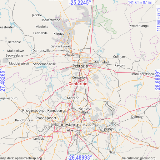
Centurion GPS coordinates[2]
25° 51' 32.076" South, 28° 11' 8.772" East
| Map corner | latitude | longitude |
|---|---|---|
| Upper-left | -25.2245°, | 27.48265° |
| Center: | -25.85891°, | 28.18577° |
| Lower-right: | -26.48993°, | 28.8889° |
| Map W x H: | 140.7×140.7 km | = 87.4×87.4mi |
| max Lat: | -22.34881° ⇑14.5% North |
| Centurion: | -25.85891° |
| min Lat: | ⇓85.5% South -34.66739° |
| min Long | Centurion | max Long |
| 16.8697° | 28.18577° | 32.26762° |
| W 60.5%⇐ | ⇒39.5% E |
Elevation
Elevation of Centurion is 1432 m = 4698 ft, and this is 462.4 m = 1517 ft above average elevation for this country.
| Max E: |
1873 m = 6145 ft | 24.2% |
| Centurion | 1432 m 4698 ft | |
| Avg. | 969.6 m = 3181 ft | |
Min E: |
7 m = 23 ft | 75.8% |
See also: Centurion elevation on elevation.city.
Geographical zone
Centurion is located in South temperate zone (between Tropic of Capricorn and the Antarctic Circle). Distance of this Southern Tropic circle is 269.3 km =167.3 mi to North.| Distance of | km | miles | from Centurion |
|---|---|---|---|
| Equator | 2875.2 | 1786.6 | to North |
| Tropic Capricorn | 269.3 | 167.3 | to North |
| Antarctic Circle | 4525.9 | 2812.3 | to South |
| South Pole | 7131.8 | 4431.5 | to South |


Nearby cities:
15 places around Centurion: (largest is in red/bold)
• Benoni
39 km =24.2 mi,  159°
159°
• Boksburg
39.9 km =24.8 mi,  169°
169°
• Cullinan
39.8 km =24.7 mi,  58°
58°
• Diepsloot
19.2 km =11.9 mi,  244°
244°
• Eastleigh
30.3 km =18.8 mi,  185°
185°
• Eden Glen
30.4 km =18.9 mi,  183°
183°
• Eden Glen Ext 60
29.8 km =18.5 mi, 183°
• Edenvale
31.5 km =19.6 mi, 186°
• Ga-Rankuwa
33 km =20.5 mi,  324°
324°
• Midrand
15.6 km =9.7 mi,  201°
201°
• Midstream
6.8 km =4.2 mi, 168°
• Modderfontein
25.7 km =16 mi, 184°
• Pretoria
12.7 km =7.9 mi,  0°
0°
• Randburg
32 km =19.9 mi,  215°
215°
• Tembisa
15.8 km =9.8 mi, 164°
Sources, notices
• [Note1] Compared only with cities in South Africa existing in our database
• [Src1] Map data: © OpenStreetMap contributors (CC-BY-SA)
• [Src2] Other city data from geonames.org with taken over terms of usage.
• [Src3] Geographical zone / Annual Mean Temperature by Robert A. Rohde @ Wikipedia
