Alice geodata
Alice (Eastern Cape) is a populated place; located in South Africa in Africa/Johannesburg (GMT+2) time zone. With population of 9,788 people, there are 220 cities with bigger population in this country. Compared to other cities in South Africa, 83.2% of cities are located further ↑North; 61.1% of cities are located further →East and 74.9% of cities have higher elevation than Alice. Note1
Administrative division(s):
- Level 1: Eastern Cape
- Level 2: Amathole District Municipality
- Level 3: Nkonkobe


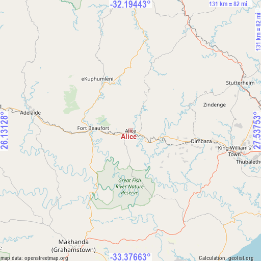
Alice GPS coordinates[2]
32° 47' 14.964" South, 26° 50' 3.84" East
| Map corner | latitude | longitude |
|---|---|---|
| Upper-left | -32.19443°, | 26.13128° |
| Center: | -32.78749°, | 26.8344° |
| Lower-right: | -33.37663°, | 27.53753° |
| Map W x H: | 131.4×131.4 km | = 81.6×81.6mi |
| max Lat: | -22.34881° ⇑83.2% North |
| Alice: | -32.78749° |
| min Lat: | ⇓16.8% South -34.66739° |
| min Long | Alice | max Long |
| 16.8697° | 26.8344° | 32.26762° |
| W 38.9%⇐ | ⇒61.1% E |
Elevation
Elevation of Alice is 522 m = 1713 ft, and this is 447.6 m = 1469 ft below average elevation for this country.
| Max E: |
1873 m = 6145 ft | 74.9% |
| Avg. | 969.6 m = 3181 ft | |
| Alice | 522 m = 1713 ft | |
Min E: |
7 m = 23 ft | 25.1% |
See also: South Africa elevation on elevation.city.
Geographical zone
Alice is located in South temperate zone (between Tropic of Capricorn and the Antarctic Circle). Distance of this Southern Tropic circle is 1039.7 km =646 mi to North.| Distance of | km | miles | from Alice |
|---|---|---|---|
| Equator | 3645.6 | 2265.3 | to North |
| Tropic Capricorn | 1039.7 | 646 | to North |
| Antarctic Circle | 3755.5 | 2333.6 | to South |
| South Pole | 6361.4 | 3952.8 | to South |


Nearby cities:
15 places around Alice: (largest is in red/bold)
• Adelaide
51.2 km =31.8 mi,  280°
280°
• Bhisho
57.2 km =35.5 mi,  96°
96°
• Cofimvaba
112 km =69.6 mi,  38°
38°
• East London
103.7 km =64.4 mi, 104°
• Fort Beaufort
18.8 km =11.7 mi,  274°
274°
• Grahamstown
64 km =39.8 mi,  206°
206°
• Ilinge
92.2 km =57.3 mi,  12°
12°
• Komga
101.7 km =63.2 mi,  76°
76°
• Peddie
52.8 km =32.8 mi,  150°
150°
• Port Alfred
88.9 km =55.2 mi,  177°
177°
• Queensdale
102.8 km =63.9 mi, 7°
• Queenstown
99 km =61.5 mi,  2°
2°
• Stutterheim
60.2 km =37.4 mi,  66°
66°
• Tarkastad
102 km =63.4 mi,  328°
328°
• Whittlesea
68 km =42.3 mi,  359°
359°
Sources, notices
• [Note1] Compared only with cities in South Africa existing in our database
• [Src1] Map data: © OpenStreetMap contributors (CC-BY-SA)
• [Src2] Other city data from geonames.org with taken over terms of usage.
• [Src3] Geographical zone / Annual Mean Temperature by Robert A. Rohde @ Wikipedia
