Fort Beaufort geodata
Fort Beaufort (Eastern Cape) is a seat of a third-order administrative division; located in South Africa in Africa/Johannesburg (GMT+2) time zone. With population of 58,419 people, there are 86 cities with bigger population in this country. Compared to other cities in South Africa, 82.9% of cities are located further ↑North; 64.9% of cities are located further →East and 77.6% of cities have higher elevation than Fort Beaufort. Note1
Administrative division(s):
- Level 1: Eastern Cape
- Level 2: Amathole District Municipality
- Level 3: Nkonkobe


Fort Beaufort GPS coordinates[2]
32° 46' 29.172" South, 26° 38' 1.536" East
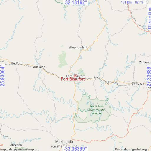
| Map corner | latitude | longitude |
|---|---|---|
| Upper-left | -32.18162°, | 25.93064° |
| Center: | -32.77477°, | 26.63376° |
| Lower-right: | -33.36399°, | 27.33689° |
| Map W x H: | 131.5×131.5 km | = 81.7×81.7mi |
| max Lat: | -22.34881° ⇑82.9% North |
| Fort Beaufort: | -32.77477° |
| min Lat: | ⇓17.1% South -34.66739° |
| min Long | Fort Beaufort | max Long |
| 16.8697° | 26.63376° | 32.26762° |
| W 35.1%⇐ | ⇒64.9% E |
Elevation
Elevation of Fort Beaufort is 444 m = 1457 ft, and this is 525.6 m = 1724 ft below average elevation for this country.
| Max E: |
1873 m = 6145 ft | 77.6% |
| Avg. | 969.6 m = 3181 ft | |
| Fort Beaufort | 444 m = 1457 ft | |
Min E: |
7 m = 23 ft | 22.4% |
See also: Fort Beaufort elevation on elevation.city.
Geographical zone
Fort Beaufort is located in South temperate zone (between Tropic of Capricorn and the Antarctic Circle). Distance of this Southern Tropic circle is 1038.3 km =645.2 mi to North.| Distance of | km | miles | from Fort Beaufort |
|---|---|---|---|
| Equator | 3644.2 | 2264.4 | to North |
| Tropic Capricorn | 1038.3 | 645.2 | to North |
| Antarctic Circle | 3757 | 2334.5 | to South |
| South Pole | 6362.8 | 3953.7 | to South |


Nearby cities:
15 places around Fort Beaufort: (largest is in red/bold)
• Adelaide
32.5 km =20.2 mi,  283°
283°
• Alice
18.8 km =11.7 mi,  94°
94°
• Bhisho
76 km =47.2 mi,  96°
96°
• Cradock
116.9 km =72.6 mi,  305°
305°
• Grahamstown
59.6 km =37 mi,  189°
189°
• Ilinge
96.7 km =60.1 mi,  23°
23°
• Komga
119.8 km =74.4 mi,  79°
79°
• Peddie
65.2 km =40.5 mi,  136°
136°
• Port Alfred
93.1 km =57.8 mi,  165°
165°
• Queensdale
105.6 km =65.6 mi, 17°
• Queenstown
100.1 km =62.2 mi,  13°
13°
• Somerset East
98 km =60.9 mi,  273°
273°
• Stutterheim
77.4 km =48.1 mi,  72°
72°
• Tarkastad
92.1 km =57.2 mi,  337°
337°
• Whittlesea
68.9 km =42.8 mi, 15°
Sources, notices
• [Note1] Compared only with cities in South Africa existing in our database
• [Src1] Map data: © OpenStreetMap contributors (CC-BY-SA)
• [Src2] Other city data from geonames.org with taken over terms of usage.
• [Src3] Geographical zone / Annual Mean Temperature by Robert A. Rohde @ Wikipedia
