Meyerton geodata
Meyerton (Gauteng) is a seat of a third-order administrative division; located in South Africa in Africa/Johannesburg (GMT+2) time zone. In our database, there are 257 cities with bigger population. Compared to other cities in South Africa, 72.6% of cities are located further ↓South; 56.3% of cities are located further ←West and 78.5% of cities have lower elevation than Meyerton. Note1
Administrative division(s):
- Level 1: Gauteng
- Level 2: Sedibeng District Municipality
- Level 3: Midvaal


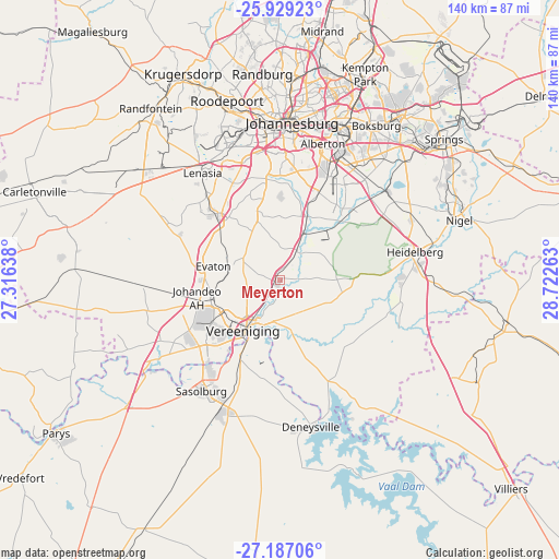
Meyerton GPS coordinates[2]
26° 33' 35.532" South, 28° 1' 10.2" East
| Map corner | latitude | longitude |
|---|---|---|
| Upper-left | -25.92923°, | 27.31638° |
| Center: | -26.55987°, | 28.0195° |
| Lower-right: | -27.18706°, | 28.72263° |
| Map W x H: | 139.9×139.9 km | = 86.9×86.9mi |
| max Lat: | -22.34881° ⇑27.4% North |
| Meyerton: | -26.55987° |
| min Lat: | ⇓72.6% South -34.66739° |
| min Long | Meyerton | max Long |
| 16.8697° | 28.0195° | 32.26762° |
| W 56.3%⇐ | ⇒43.7% E |
Elevation
Elevation of Meyerton is 1473 m = 4833 ft, and this is 503.4 m = 1652 ft above average elevation for this country.
| Max E: |
1873 m = 6145 ft | 21.5% |
| Meyerton | 1473 m 4833 ft | |
| Avg. | 969.6 m = 3181 ft | |
Min E: |
7 m = 23 ft | 78.5% |
See also: South Africa elevation on elevation.city.
Geographical zone
Meyerton is located in South temperate zone (between Tropic of Capricorn and the Antarctic Circle). Distance of this Southern Tropic circle is 347.3 km =215.8 mi to North.| Distance of | km | miles | from Meyerton |
|---|---|---|---|
| Equator | 2953.2 | 1835 | to North |
| Tropic Capricorn | 347.3 | 215.8 | to North |
| Antarctic Circle | 4448 | 2763.9 | to South |
| South Pole | 7053.9 | 4383.1 | to South |


Nearby cities:
15 places around Meyerton: (largest is in red/bold)
• Alberton
34 km =21.1 mi,  17°
17°
• Boksburg
45.5 km =28.3 mi,  31°
31°
• Deneysville
37.6 km =23.4 mi,  168°
168°
• Germiston
39.4 km =24.5 mi, 23°
• Heidelberg
34.3 km =21.3 mi,  79°
79°
• Johannesburg
39.8 km =24.7 mi,  3°
3°
• Nigel
47.7 km =29.6 mi,  72°
72°
• Orange Farm
17.4 km =10.8 mi,  299°
299°
• Riverlea
39 km =24.2 mi,  353°
353°
• Roodepoort
46.5 km =28.9 mi,  341°
341°
• Sasolburg
34.7 km =21.6 mi,  215°
215°
• Soweto
36.2 km =22.5 mi,  333°
333°
• Vanderbijlpark
24.7 km =15.3 mi,  226°
226°
• Vereeniging
15.6 km =9.7 mi, 216°
• Westonaria
45.6 km =28.3 mi,  305°
305°
Sources, notices
• [Note1] Compared only with cities in South Africa existing in our database
• [Src1] Map data: © OpenStreetMap contributors (CC-BY-SA)
• [Src2] Other city data from geonames.org with taken over terms of usage.
• [Src3] Geographical zone / Annual Mean Temperature by Robert A. Rohde @ Wikipedia
