Balfour geodata
Balfour (Mpumalanga) is a seat of a third-order administrative division; located in South Africa in Africa/Johannesburg (GMT+2) time zone. With population of 46,008 people, there are 96 cities with bigger population in this country. Compared to other cities in South Africa, 72% of cities are located further ↓South; 65.8% of cities are located further ←West and 91.2% of cities have lower elevation than Balfour. Note1
Administrative division(s):
- Level 1: Mpumalanga
- Level 2: Gert Sibande District Municipality
- Level 3: Dipaleseng


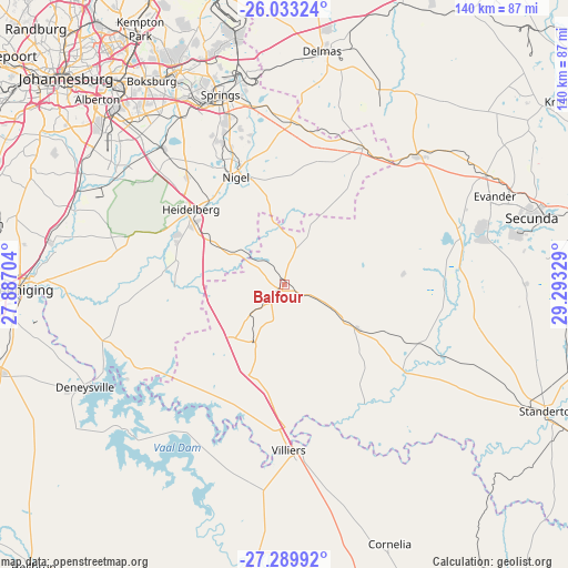
Balfour GPS coordinates[2]
26° 39' 47.916" South, 28° 35' 24.576" East
| Map corner | latitude | longitude |
|---|---|---|
| Upper-left | -26.03324°, | 27.88704° |
| Center: | -26.66331°, | 28.59016° |
| Lower-right: | -27.28992°, | 29.29329° |
| Map W x H: | 139.7×139.7 km | = 86.8×86.8mi |
| max Lat: | -22.34881° ⇑28% North |
| Balfour: | -26.66331° |
| min Lat: | ⇓72% South -34.66739° |
| min Long | Balfour | max Long |
| 16.8697° | 28.59016° | 32.26762° |
| W 65.8%⇐ | ⇒34.2% E |
Elevation
Elevation of Balfour is 1622 m = 5322 ft, and this is 652.4 m = 2140 ft above average elevation for this country.
| Max E: |
1873 m = 6145 ft | 8.8% |
| Balfour | 1622 m 5322 ft | |
| Avg. | 969.6 m = 3181 ft | |
Min E: |
7 m = 23 ft | 91.2% |
See also: Balfour elevation on elevation.city.
Geographical zone
Balfour is located in South temperate zone (between Tropic of Capricorn and the Antarctic Circle). Distance of this Southern Tropic circle is 358.8 km =222.9 mi to North.| Distance of | km | miles | from Balfour |
|---|---|---|---|
| Equator | 2964.7 | 1842.2 | to North |
| Tropic Capricorn | 358.8 | 222.9 | to North |
| Antarctic Circle | 4436.5 | 2756.7 | to South |
| South Pole | 7042.4 | 4375.9 | to South |


Nearby cities:
15 places around Balfour: (largest is in red/bold)
• Alberton
64.1 km =39.8 mi,  313°
313°
• Benoni
59.2 km =36.8 mi,  333°
333°
• Boksburg
60 km =37.3 mi, 326°
• Brakpan
52.3 km =32.5 mi,  335°
335°
• Delmas
58.2 km =36.2 mi,  9°
9°
• Deneysville
55.1 km =34.2 mi,  242°
242°
• Germiston
63 km =39.1 mi,  319°
319°
• Heidelberg
29 km =18 mi, 307°
• Meyerton
57.9 km =36 mi,  281°
281°
• Nigel
28.1 km =17.5 mi, 336°
• Secunda
58.7 km =36.5 mi,  77°
77°
• Springs
49.7 km =30.9 mi, 337°
• Vereeniging
66 km =41 mi,  269°
269°
• Villiers
40.8 km =25.4 mi,  178°
178°
• eMbalenhle
49.5 km =30.8 mi,  73°
73°
Sources, notices
• [Note1] Compared only with cities in South Africa existing in our database
• [Src1] Map data: © OpenStreetMap contributors (CC-BY-SA)
• [Src2] Other city data from geonames.org with taken over terms of usage.
• [Src3] Geographical zone / Annual Mean Temperature by Robert A. Rohde @ Wikipedia
