Howick geodata
Howick (KwaZulu-Natal) is a seat of a third-order administrative division; located in South Africa in Africa/Johannesburg (GMT+2) time zone. With population of 28,725 people, there are 125 cities with bigger population in this country. Compared to other cities in South Africa, 60.2% of cities are located further ↑North; 84.1% of cities are located further ←West and 54.3% of cities have higher elevation than Howick. Note1
Administrative division(s):
- Level 1: KwaZulu-Natal
- Level 2: uMgungundlovu District Municipality
- Level 3: uMngeni


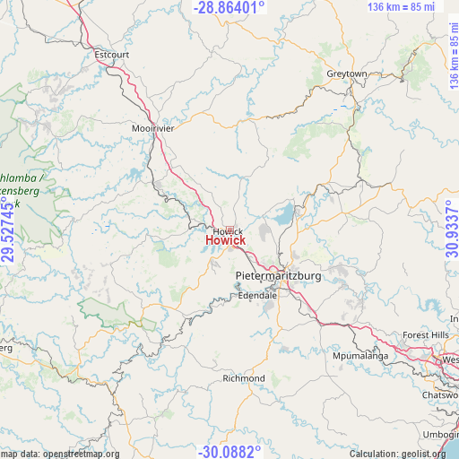
Howick GPS coordinates[2]
29° 28' 40.62" South, 30° 13' 50.052" East
| Map corner | latitude | longitude |
|---|---|---|
| Upper-left | -28.86401°, | 29.52745° |
| Center: | -29.47795°, | 30.23057° |
| Lower-right: | -30.0882°, | 30.9337° |
| Map W x H: | 136.1×136.1 km | = 84.6×84.6mi |
| max Lat: | -22.34881° ⇑60.2% North |
| Howick: | -29.47795° |
| min Lat: | ⇓39.8% South -34.66739° |
| min Long | Howick | max Long |
| 16.8697° | 30.23057° | 32.26762° |
| W 84.1%⇐ | ⇒15.9% E |
Elevation
Elevation of Howick is 1048 m = 3438 ft, and this is 78.4 m = 257 ft above average elevation for this country.
| Max E: |
1873 m = 6145 ft | 54.3% |
| Howick | 1048 m 3438 ft | |
| Avg. | 969.6 m = 3181 ft | |
Min E: |
7 m = 23 ft | 45.7% |
See also: South Africa elevation on elevation.city.
Geographical zone
Howick is located in South temperate zone (between Tropic of Capricorn and the Antarctic Circle). Distance of this Southern Tropic circle is 671.7 km =417.4 mi to North.| Distance of | km | miles | from Howick |
|---|---|---|---|
| Equator | 3277.6 | 2036.6 | to North |
| Tropic Capricorn | 671.7 | 417.4 | to North |
| Antarctic Circle | 4123.5 | 2562.2 | to South |
| South Pole | 6729.4 | 4181.5 | to South |


Nearby cities:
15 places around Howick: (largest is in red/bold)
• Camperdown
41.1 km =25.5 mi,  132°
132°
• Creighton
71.8 km =44.6 mi,  211°
211°
• Estcourt
62.7 km =39 mi,  325°
325°
• Greytown
57.9 km =36 mi,  37°
37°
• Himeville
75.5 km =46.9 mi,  246°
246°
• Impendle
37.8 km =23.5 mi, 248°
• Ixopo
76.1 km =47.3 mi,  190°
190°
• Mooirivier
37.7 km =23.4 mi,  322°
322°
• Mpophomeni
10.9 km =6.8 mi,  203°
203°
• Mpumalanga
54.1 km =33.6 mi, 133°
• Ndwedwe
67.5 km =41.9 mi,  93°
93°
• Pietermaritzburg
22 km =13.7 mi, 134°
• Richmond
44 km =27.3 mi,  174°
174°
• Tugela Ferry
84.1 km =52.3 mi,  14°
14°
• Wartburg
33.8 km =21 mi,  81°
81°
Sources, notices
• [Note1] Compared only with cities in South Africa existing in our database
• [Src1] Map data: © OpenStreetMap contributors (CC-BY-SA)
• [Src2] Other city data from geonames.org with taken over terms of usage.
• [Src3] Geographical zone / Annual Mean Temperature by Robert A. Rohde @ Wikipedia
