Mpumalanga geodata
Mpumalanga (KwaZulu-Natal) is a populated place; located in South Africa in Africa/Johannesburg (GMT+2) time zone. With population of 140,121 people, there are 38 cities with bigger population in this country. Compared to other cities in South Africa, 64% of cities are located further ↑North; 88.8% of cities are located further ←West and 69.3% of cities have higher elevation than Mpumalanga. Note1
Administrative division(s):
- Level 1: KwaZulu-Natal
- Level 2: eThekwini Metropolitan Municipality
- Level 3: Ethekwini


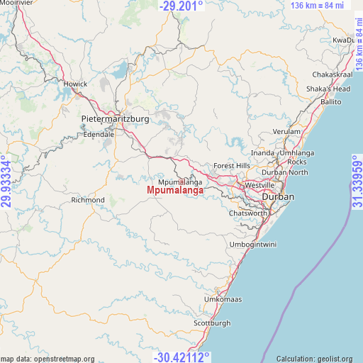
Mpumalanga GPS coordinates[2]
29° 48' 46.512" South, 30° 38' 11.256" East
| Map corner | latitude | longitude |
|---|---|---|
| Upper-left | -29.201°, | 29.93334° |
| Center: | -29.81292°, | 30.63646° |
| Lower-right: | -30.42112°, | 31.33959° |
| Map W x H: | 135.7×135.7 km | = 84.3×84.3mi |
| max Lat: | -22.34881° ⇑64% North |
| Mpumalanga: | -29.81292° |
| min Lat: | ⇓36% South -34.66739° |
| min Long | Mpumalanga | max Long |
| 16.8697° | 30.63646° | 32.26762° |
| W 88.8%⇐ | ⇒11.2% E |
Elevation
Elevation of Mpumalanga is 711 m = 2333 ft, and this is 258.6 m = 848 ft below average elevation for this country.
| Max E: |
1873 m = 6145 ft | 69.3% |
| Avg. | 969.6 m = 3181 ft | |
| Mpumalanga | 711 m = 2333 ft | |
Min E: |
7 m = 23 ft | 30.7% |
See also: Mpumalanga elevation on elevation.city.
Geographical zone
Mpumalanga is located in South temperate zone (between Tropic of Capricorn and the Antarctic Circle). Distance of this Southern Tropic circle is 709 km =440.6 mi to North.| Distance of | km | miles | from Mpumalanga |
|---|---|---|---|
| Equator | 3314.9 | 2059.8 | to North |
| Tropic Capricorn | 709 | 440.6 | to North |
| Antarctic Circle | 4086.3 | 2539.1 | to South |
| South Pole | 6692.2 | 4158.3 | to South |


Nearby cities:
15 places around Mpumalanga: (largest is in red/bold)
• Ballito
63.6 km =39.5 mi,  61°
61°
• Berea
34.7 km =21.6 mi,  97°
97°
• Camperdown
13 km =8.1 mi,  315°
315°
• Durban
38.2 km =23.7 mi, 97°
• Howick
54.1 km =33.6 mi,  313°
313°
• Impendle
78.1 km =48.5 mi,  287°
287°
• Ixopo
65.1 km =40.5 mi,  234°
234°
• Mpophomeni
51.3 km =31.9 mi,  302°
302°
• Ndwedwe
43.3 km =26.9 mi,  40°
40°
• Pietermaritzburg
32.1 km =19.9 mi, 312°
• Richmond
35.7 km =22.2 mi,  259°
259°
• Scottburgh
53.9 km =33.5 mi,  167°
167°
• Tongaat Beach
54.6 km =33.9 mi,  66°
66°
• Wartburg
42.8 km =26.6 mi,  352°
352°
• eMkhomazi
46.5 km =28.9 mi,  160°
160°
Sources, notices
• [Note1] Compared only with cities in South Africa existing in our database
• [Src1] Map data: © OpenStreetMap contributors (CC-BY-SA)
• [Src2] Other city data from geonames.org with taken over terms of usage.
• [Src3] Geographical zone / Annual Mean Temperature by Robert A. Rohde @ Wikipedia
