Sharan geodata
Sharan (Paktika) is a seat of a first-order administrative division; located in Afghanistan in Asia/Kabul (GMT+4.5) time zone. With population of 2,200 people, there are 88 cities with bigger population in this country. Compared to other cities in Afghanistan, 80.1% of cities are located further ↑North; 53.4% of cities are located further ←West and 81.7% of cities have lower elevation than Sharan. Note1


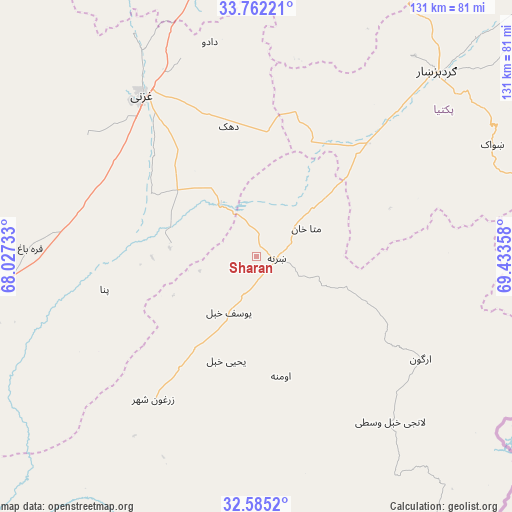
Sharan GPS coordinates[2]
33° 10' 32.448" North, 68° 43' 49.62" East
| Map corner | latitude | longitude |
|---|---|---|
| Upper-left | 33.76221°, | 68.02733° |
| Center: | 33.17568°, | 68.73045° |
| Lower-right: | 32.5852°, | 69.43358° |
| Map W x H: | 130.9×130.9 km | = 81.3×81.3mi |
| max Lat: | 38.4435° ⇑80.1% North |
| Sharan: | 33.17568° |
| min Lat: | ⇓19.9% South 30.15° |
| min Long | Sharan | max Long |
| 61.06667° | 68.73045° | 72.318° |
| W 53.4%⇐ | ⇒46.6% E |
Elevation
Elevation of Sharan is 2145 m = 7037 ft, and this is 726.6 m = 2384 ft above average elevation for this country.
| Max E: |
3068 m = 10066 ft | 18.3% |
| Sharan | 2145 m 7037 ft | |
| Avg. | 1418.4 m = 4654 ft | |
Min E: |
254 m = 833 ft | 81.7% |
See also: Afghanistan elevation on elevation.city.
Geographical zone
Sharan is located in North temperate zone (between Tropic of Cancer and the Arctic Circle). Distance of this Northern Tropic circle is 1082.9 km =672.9 mi to South.| Distance of | km | miles | from Sharan |
|---|---|---|---|
| North Pole | 6318.3 | 3926 | to North |
| Arctic Circle | 3712.4 | 2306.8 | to North |
| Tropic Cancer | 1082.9 | 672.9 | to South |
| Equator | 3688.8 | 2292.1 | to South |


Nearby cities:
15 places around Sharan: (largest is in red/bold)
• Ghazni
50.9 km =31.6 mi,  325°
325°
• Khayr Kōṯ
44.4 km =27.6 mi,  216°
216°
• Mutā Khān
14.5 km =9 mi,  60°
60°
• Mīray
31.6 km =19.6 mi,  301°
301°
• Nīkêh
50.4 km =31.3 mi,  88°
88°
• Rāmak
39.7 km =24.7 mi,  345°
345°
• Urgun
49 km =30.4 mi,  120°
120°
• Yaḩyá Khēl
27.6 km =17.1 mi,  196°
196°
• Zarghūn Shahr
45.1 km =28 mi, 216°
• Zaṟah Sharan
6.6 km =4.1 mi, 119°
• Zerok-Alakadari
54.2 km =33.7 mi, 92°
• Zurmat
40.2 km =25 mi,  43°
43°
• Ōmnah
31.2 km =19.4 mi,  168°
168°
• ‘Alāqahdārī Saṟōbī
54 km =33.6 mi,  141°
141°
• ‘Alāqahdārī Yōsuf Khēl
15.7 km =9.8 mi,  208°
208°
Sources, notices
• [Note1] Compared only with cities in Afghanistan existing in our database
• [Src1] Map data: © OpenStreetMap contributors (CC-BY-SA)
• [Src2] Other city data from geonames.org with taken over terms of usage.
• [Src3] Geographical zone / Annual Mean Temperature by Robert A. Rohde @ Wikipedia
