Ghazni geodata
Ghazni is a seat of a first-order administrative division; located in Afghanistan in Asia/Kabul (GMT+4.5) time zone. With population of 141,000 people, there are 6 cities with bigger population in this country. Compared to other cities in Afghanistan, 73% of cities are located further ↑North; 51.1% of cities are located further →East and 83% of cities have lower elevation than Ghazni. Note1


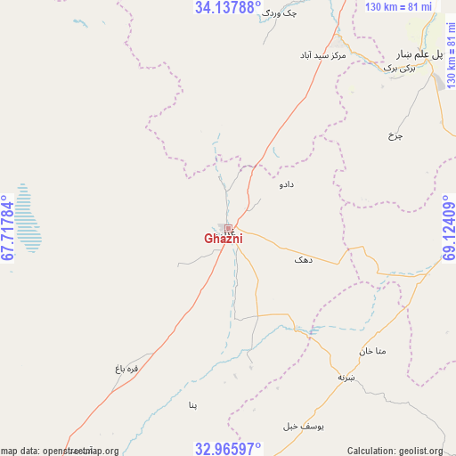
Ghazni GPS coordinates[2]
33° 33' 14.076" North, 68° 25' 15.456" East
| Map corner | latitude | longitude |
|---|---|---|
| Upper-left | 34.13788°, | 67.71784° |
| Center: | 33.55391°, | 68.42096° |
| Lower-right: | 32.96597°, | 69.12409° |
| Map W x H: | 130.3×130.3 km | = 81×81mi |
| max Lat: | 38.4435° ⇑73% North |
| Ghazni: | 33.55391° |
| min Lat: | ⇓27% South 30.15° |
| min Long | Ghazni | max Long |
| 61.06667° | 68.42096° | 72.318° |
| W 48.9%⇐ | ⇒51.1% E |
Elevation
Elevation of Ghazni is 2179 m = 7149 ft, and this is 760.6 m = 2495 ft above average elevation for this country.
| Max E: |
3068 m = 10066 ft | 17% |
| Ghazni | 2179 m 7149 ft | |
| Avg. | 1418.4 m = 4654 ft | |
Min E: |
254 m = 833 ft | 83% |
See also: Ghazni elevation on elevation.city.
Geographical zone
Ghazni is located in North temperate zone (between Tropic of Cancer and the Arctic Circle). Distance of this Northern Tropic circle is 1124.9 km =699 mi to South.| Distance of | km | miles | from Ghazni |
|---|---|---|---|
| North Pole | 6276.2 | 3899.8 | to North |
| Arctic Circle | 3670.3 | 2280.6 | to North |
| Tropic Cancer | 1124.9 | 699 | to South |
| Equator | 3730.8 | 2318.2 | to South |


Nearby cities:
15 places around Ghazni: (largest is in red/bold)
• Baraki Barak
67.1 km =41.7 mi,  46°
46°
• Chahār Qal‘ah
11.4 km =7.1 mi,  269°
269°
• Charkh
54.9 km =34.1 mi,  60°
60°
• Kalān Deh
31.5 km =19.6 mi,  356°
356°
• Markaz-e Sayyidābād
56.5 km =35.1 mi,  28°
28°
• Mutā Khān
54.1 km =33.6 mi,  130°
130°
• Mīray
25.6 km =15.9 mi,  175°
175°
• Qarah Bāgh
49.1 km =30.5 mi,  216°
216°
• Rāmak
19.4 km =12.1 mi,  100°
100°
• Sharan
50.9 km =31.6 mi,  145°
145°
• Tōrmay
15.1 km =9.4 mi,  353°
353°
• Zaṟah Sharan
56.9 km =35.4 mi,  142°
142°
• Zurmat
57.7 km =35.9 mi, 102°
• Ōkak
57.5 km =35.7 mi,  311°
311°
• ‘Alāqahdārī Yōsuf Khēl
59.7 km =37.1 mi,  159°
159°
Sources, notices
• [Note1] Compared only with cities in Afghanistan existing in our database
• [Src1] Map data: © OpenStreetMap contributors (CC-BY-SA)
• [Src2] Other city data from geonames.org with taken over terms of usage.
• [Src3] Geographical zone / Annual Mean Temperature by Robert A. Rohde @ Wikipedia
