Zerok-Alakadari geodata
Zerok-Alakadari (Paktika) is a seat of a second-order administrative division; located in Afghanistan in Asia/Kabul (GMT+4.5) time zone. In our database, there are 93 cities with bigger population. Compared to other cities in Afghanistan, 80.4% of cities are located further ↑North; 68.5% of cities are located further ←West and 89.1% of cities have lower elevation than Zerok-Alakadari. Note1


Zerok-Alakadari GPS coordinates[2]
33° 9' 29.016" North, 69° 18' 46.008" East
| Map corner | latitude | longitude |
|---|---|---|
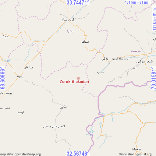
| Upper-left | 33.74471°, | 68.60966° |
| Center: | 33.15806°, | 69.31278° |
| Lower-right: | 32.56746°, | 70.01591° |
| Map W x H: | 130.9×130.9 km | = 81.3×81.3mi |
| max Lat: | 38.4435° ⇑80.4% North |
| Zerok-Alakadari: | 33.15806° |
| min Lat: | ⇓19.6% South 30.15° |
| min Long | Zerok-Alakadari | max Long |
| 61.06667° | 69.31278° | 72.318° |
| W 68.5%⇐ | ⇒31.5% E |
Elevation
Elevation of Zerok-Alakadari is 2336 m = 7664 ft, and this is 917.6 m = 3010 ft above average elevation for this country.
| Max E: |
3068 m = 10066 ft | 10.9% |
| Zerok-Alakadari | 2336 m 7664 ft | |
| Avg. | 1418.4 m = 4654 ft | |
Min E: |
254 m = 833 ft | 89.1% |
See also: Afghanistan elevation on elevation.city.
Geographical zone
Zerok-Alakadari is located in North temperate zone (between Tropic of Cancer and the Arctic Circle). Distance of this Northern Tropic circle is 1080.9 km =671.6 mi to South.| Distance of | km | miles | from Zerok-Alakadari |
|---|---|---|---|
| North Pole | 6320.2 | 3927.2 | to North |
| Arctic Circle | 3714.3 | 2308 | to North |
| Tropic Cancer | 1080.9 | 671.6 | to South |
| Equator | 3686.8 | 2290.9 | to South |


Nearby cities:
15 places around Zerok-Alakadari: (largest is in red/bold)
• Dwah Manḏay
28.8 km =17.9 mi,  61°
61°
• Gardez
49.5 km =30.8 mi,  350°
350°
• Mutā Khān
42.5 km =26.4 mi,  282°
282°
• Nīkêh
5.2 km =3.2 mi,  312°
312°
• Salām Khēl
57 km =35.4 mi,  1°
1°
• Sharan
54.2 km =33.7 mi,  272°
272°
• Shaykh Amīr Kêlay
57.6 km =35.8 mi,  75°
75°
• Shwāk
30.1 km =18.7 mi,  11°
11°
• Spērah
19.5 km =12.1 mi, 75°
• Stêr Giyān
20.9 km =13 mi,  164°
164°
• Urgun
26 km =16.2 mi,  207°
207°
• Zaṟah Sharan
48.5 km =30.1 mi, 268°
• Zurmat
40.9 km =25.4 mi,  319°
319°
• Ōmnah
56 km =34.8 mi,  239°
239°
• ‘Alāqahdārī Saṟōbī
45.7 km =28.4 mi, 207°
Sources, notices
• [Note1] Compared only with cities in Afghanistan existing in our database
• [Src1] Map data: © OpenStreetMap contributors (CC-BY-SA)
• [Src2] Other city data from geonames.org with taken over terms of usage.
• [Src3] Geographical zone / Annual Mean Temperature by Robert A. Rohde @ Wikipedia
