Qal‘ah-ye Shāhī geodata
Qal‘ah-ye Shāhī (Nangarhar) is a seat of a second-order administrative division; located in Afghanistan in Asia/Kabul (GMT+4.5) time zone. In our database, there are 93 cities with bigger population. Compared to other cities in Afghanistan, 50.8% of cities are located further ↑North; 90% of cities are located further ←West and 71.7% of cities have higher elevation than Qal‘ah-ye Shāhī. Note1


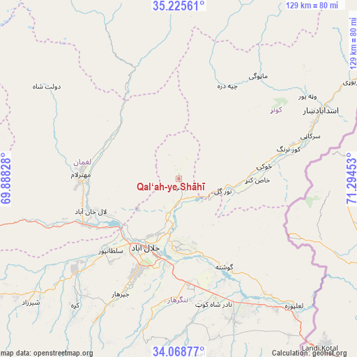
Qal‘ah-ye Shāhī GPS coordinates[2]
34° 38' 57.156" North, 70° 35' 29.04" East
| Map corner | latitude | longitude |
|---|---|---|
| Upper-left | 35.22561°, | 69.88828° |
| Center: | 34.64921°, | 70.5914° |
| Lower-right: | 34.06877°, | 71.29453° |
| Map W x H: | 128.6×128.6 km | = 79.9×79.9mi |
| max Lat: | 38.4435° ⇑50.8% North |
| Qal‘ah-ye Shāhī: | 34.64921° |
| min Lat: | ⇓49.2% South 30.15° |
| min Long | Qal‘ah-ye Sh� | max Long |
| 61.06667° | 70.5914° | 72.318° |
| W 90%⇐ | ⇒10% E |
Elevation
Elevation of Qal‘ah-ye Shāhī is 894 m = 2933 ft, and this is 524.4 m = 1720 ft below average elevation for this country.
| Max E: |
3068 m = 10066 ft | 71.7% |
| Avg. | 1418.4 m = 4654 ft | |
| Qal‘ah-ye Shāhī | 894 m = 2933 ft | |
Min E: |
254 m = 833 ft | 28.3% |
See also: Afghanistan elevation on elevation.city.
Geographical zone
Qal‘ah-ye Shāhī is located in North temperate zone (between Tropic of Cancer and the Arctic Circle). Distance of this Northern Tropic circle is 1246.7 km =774.7 mi to South.| Distance of | km | miles | from Qal‘ah-ye Shāhī |
|---|---|---|---|
| North Pole | 6154.4 | 3824.2 | to North |
| Arctic Circle | 3548.5 | 2204.9 | to North |
| Tropic Cancer | 1246.7 | 774.7 | to South |
| Equator | 3852.6 | 2393.9 | to South |


Nearby cities:
15 places around Qal‘ah-ye Shāhī: (largest is in red/bold)
• Gōshtah
36 km =22.4 mi,  154°
154°
• Jalālābād
27.9 km =17.3 mi,  207°
207°
• Kanḏay
37.9 km =23.5 mi,  26°
26°
• Khafizan
45 km =28 mi, 206°
• Manogay
47.9 km =29.8 mi,  37°
37°
• Mehtar Lām
35 km =21.7 mi,  274°
274°
• Narang
43.5 km =27 mi,  73°
73°
• Nūrgal
16.4 km =10.2 mi,  104°
104°
• Qarghah’ī
33.6 km =20.9 mi,  251°
251°
• Sangar Sarāy
27.2 km =16.9 mi,  170°
170°
• Sar Kāṉī
49.9 km =31 mi, 71°
• Sheywah
8.6 km =5.3 mi,  181°
181°
• Sulţānpūr-e ‘Ulyā
37.8 km =23.5 mi,  225°
225°
• Tsowkêy
31.1 km =19.3 mi,  81°
81°
• Wuluswālī ‘Alīngār
29.6 km =18.4 mi,  314°
314°
Sources, notices
• [Note1] Compared only with cities in Afghanistan existing in our database
• [Src1] Map data: © OpenStreetMap contributors (CC-BY-SA)
• [Src2] Other city data from geonames.org with taken over terms of usage.
• [Src3] Geographical zone / Annual Mean Temperature by Robert A. Rohde @ Wikipedia
